
Topografische Karte Grand Port
Interaktive Karte
Klicken Sie auf die Karte, um die Höhe anzuzeigen.
Über diese Karte
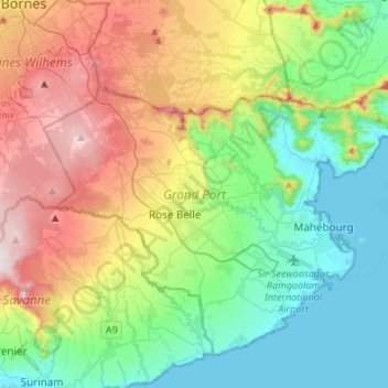
Name: Topografische Karte Grand Port, Höhe, Relief.
Ort: Grand Port, Mauritius (-20.49533 57.51077 -20.28418 57.78114)
Durchschnittliche Höhe: 244 m
Minimale Höhe: 0 m
Maximale Höhe: 715 m
Andere topografische Karten
Klicken Sie auf eine Karte, um ihre Topografie, ihre Höhe und ihr Relief anzuzeigen.
Cap Malheureux
Mauritius > Rivière du Rempart
Cap Malheureux, Rivière du Rempart, Äußere Inseln von Mauritius, 30546, Mauritius
Durchschnittliche Höhe: 4 m
Rivière du Rempart
Rivière du Rempart, Äußere Inseln von Mauritius, Mauritius
Durchschnittliche Höhe: 53 m
Rodrigues
Rodrigues, Mont Lubin, Rodrigues, Äußere Inseln von Mauritius, Mauritius
Durchschnittliche Höhe: 41 m
Mapou
Mauritius > Rivière du Rempart > Mapou
Mapou, Rivière du Rempart, 21013, Mauritius
Durchschnittliche Höhe: 93 m
Piton
Mauritius > Rivière du Rempart > Piton
Piton, Rivière du Rempart, 21013, Mauritius
Durchschnittliche Höhe: 117 m
Petit Sable
Mauritius > Grand Port > Petit Sable
Petit Sable, Grand Port, Mauritius
Durchschnittliche Höhe: 42 m
Mapou
Mauritius > Rivière du Rempart > Mapou
Mapou, Rivière du Rempart, Mauritius
Durchschnittliche Höhe: 95 m
Black River Gorges National Park
Mauritius > Black River > Chamarel
Black River Gorges National Park, Gollum trail, Chamarel, Black River, Mauritius
Durchschnittliche Höhe: 324 m
Albatros Island
Mauritius > Äußere Inseln von Mauritius
Albatros Island, Saint Brandon, Äußere Inseln von Mauritius, Mauritius
Durchschnittliche Höhe: 0 m
Grand Baie
Mauritius > Rodrigues > Grand Baie
Grand Baie, Rodrigues, Mauritius
Durchschnittliche Höhe: 93 m