
Topografische Karte Agios Andreas
Interaktive Karte
Klicken Sie auf die Karte, um die Höhe anzuzeigen.
Über diese Karte
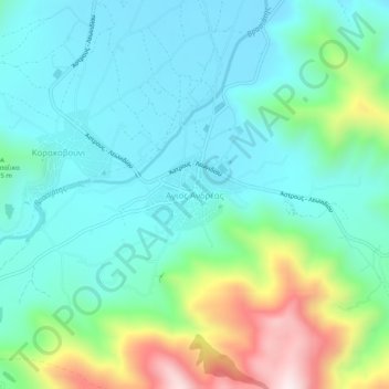
Name: Topografische Karte Agios Andreas, Höhe, Relief.
Durchschnittliche Höhe: 164 m
Minimale Höhe: 6 m
Maximale Höhe: 650 m
Andere topografische Karten
Klicken Sie auf eine Karte, um ihre Topografie, ihre Höhe und ihr Relief anzuzeigen.
Nestani
Greece > Peloponnese, Western Greece and the Ionian > Arcadia Regional Unit > Municipal Unit of Mantineia
Nestani, Municipal Unit of Mantineia, Municipality of Tripoli, Arcadia Regional Unit, Peloponnese Region, Peloponnese, Western Greece and the Ionian, 220 05, Greece
Durchschnittliche Höhe: 827 m
Tower of Nestani
Greece > Peloponnese, Western Greece and the Ionian > Arcadia Regional Unit > Municipal Unit of Mantineia
Tower of Nestani, Corinth - Tripoli - Kalamata, κ. Σάγκα, Community of Nestani, Municipal Unit of Mantineia, Municipality of Tripoli, Arcadia Regional Unit, Peloponnese Region, Peloponnese, Western Greece and the Ionian, 220 05, Greece
Durchschnittliche Höhe: 753 m
Kastri
Greece > Peloponnese, Western Greece and the Ionian > Arcadia Regional Unit
Kastri, Municipality of North Kynouria, Arcadia Regional Unit, Peloponnese Region, Peloponnese, Western Greece and the Ionian, 220 13, Greece
Durchschnittliche Höhe: 944 m
Akra
Greece > Peloponnese, Western Greece and the Ionian > Arcadia Regional Unit > Municipal Unit of Tegea
Akra, Stadio Community, Municipal Unit of Tegea, Municipality of Tripoli, Arcadia Regional Unit, Peloponnese Region, Peloponnese, Western Greece and the Ionian, 220 12, Greece
Durchschnittliche Höhe: 666 m
Astros Beach
Greece > Peloponnese, Western Greece and the Ionian > Arcadia Regional Unit
Astros Beach, Municipality of North Kynouria, Arcadia Regional Unit, Peloponnese Region, Peloponnese, Western Greece and the Ionian, 220 19, Greece
Durchschnittliche Höhe: 3 m
Tripoli
Greece > Peloponnese, Western Greece and the Ionian > Arcadia Regional Unit
Tripoli, Municipal Unit of Tripoli, Municipality of Tripoli, Arcadia Regional Unit, Peloponnese Region, Peloponnese, Western Greece and the Ionian, 221 00, Greece
Durchschnittliche Höhe: 873 m
Lousios
Greece > Peloponnese, Western Greece and the Ionian > Arcadia Regional Unit > Municipal Unit of Gortyna
Lousios, κ. Ατσιχόλου, Municipal Unit of Gortyna, Municipality of Megalopoli, Arcadia Regional Unit, Peloponnese Region, Peloponnese, Western Greece and the Ionian, 220 24, Greece
Durchschnittliche Höhe: 440 m
Megalopoli
Greece > Peloponnese, Western Greece and the Ionian > Arcadia Regional Unit > Municipal Unit of Megalopoli
Megalopoli, Municipal Unit of Megalopoli, Municipality of Megalopoli, Arcadia Regional Unit, Peloponnese Region, Peloponnese, Western Greece and the Ionian, 222 00, Greece
Durchschnittliche Höhe: 434 m
Chirades
Greece > Peloponnese, Western Greece and the Ionian > Arcadia Regional Unit > Municipal Unit of Megalopoli
Chirades, Municipal Unit of Megalopoli, Municipality of Megalopoli, Arcadia Regional Unit, Peloponnese Region, Peloponnese, Western Greece and the Ionian, 222 00, Greece
Durchschnittliche Höhe: 708 m