Geolokalisieren

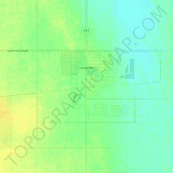
Topografische Karte Langdon

Klicken Sie auf die Karte, um die Höhe anzuzeigen.

Langdon

Langdon is located 12 km (7.5 mi) east of the City of Calgary at the intersection of Highway 560 (Glenmore Trail) and Highway 797, approximately 6 km (3.7 mi) south of the Trans Canada Highway and 7 km (4.3 mi) north of Highway 22X. It has an elevation of 1,005 m (3,297 ft).

Wikipedia (CC-BY-SA 3.0)

Über diese Karte

Name: Topografische Karte Langdon, Höhe, Relief.

Ort: Langdon, Rocky View County, Alberta, Canada (50.95799 -113.72599 50.97955 -113.64409)

Durchschnittliche Höhe: 1.007 m

Minimale Höhe: 998 m

Maximale Höhe: 1.016 m

Andere topografische Karten

Klicken Sie auf eine Karte, um ihre Topografie, ihre Höhe und ihr Relief anzuzeigen.

Redwood Meadows

Canada > Alberta > Rocky View County

Durchschnittliche Höhe: 1.278 m

Cochrane Lake

Canada > Alberta > Rocky View County

Durchschnittliche Höhe: 1.292 m

Harmony

Canada > Alberta > Rocky View County

Durchschnittliche Höhe: 1.191 m

Bragg Creek

Canada > Alberta > Rocky View County

Durchschnittliche Höhe: 1.332 m

Madden

Canada > Alberta > Rocky View County

Durchschnittliche Höhe: 1.151 m

Jumping Pound

Canada > Alberta > Rocky View County

Durchschnittliche Höhe: 1.249 m

Balzac

Canada > Alberta > Rocky View County

Durchschnittliche Höhe: 1.088 m

Rüsten Sie sich für Ihr nächstes Abenteuer:

🧢Outdoor Cap - Sonnenschutz Cap für Wanderungen
🧣Rettungsdecken - Schutz vor Auskühlung in Notsituationen
🥤Thermoskanne Outdoor - Isolierte Thermoskanne für heiße/kalte Getränke
🔭Ferngläser 8x42 - Der Allrounder für Natur- und Geländebeobachtung
📊Adventure Buch Tipps - Inspiration & Ratgeber für Outdoor Fans

Als Amazon-Partner erhält diese Website eine Provision für qualifizierte Käufe, ohne zusätzliche Kosten für Sie.