
Topografische Karte Dolancourt
Interaktive Karte
Klicken Sie auf die Karte, um die Höhe anzuzeigen.
Über diese Karte
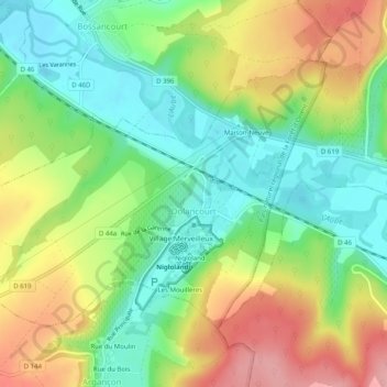
Name: Topografische Karte Dolancourt, Höhe, Relief.
Durchschnittliche Höhe: 197 m
Minimale Höhe: 143 m
Maximale Höhe: 272 m
Andere topografische Karten
Klicken Sie auf eine Karte, um ihre Topografie, ihre Höhe und ihr Relief anzuzeigen.
Le Village
France > Grand Est > Aube > Dolancourt
Le Village, Dolancourt, Bar-sur-Aube, Aube, Grand Est, Metropolitan France, 10200, France
Durchschnittliche Höhe: 203 m
Metz-Robert
Metz-Robert, Troyes, Aube, Grand Est, Metropolitan France, 10210, France
Durchschnittliche Höhe: 153 m
Maizières-la-Grande-Paroisse
France > Grand Est > Aube > Maizières-la-Grande-Paroisse
Maizières-la-Grande-Paroisse, Nogent-sur-Seine, Aube, Grand Est, Metropolitan France, 10510, France
Durchschnittliche Höhe: 80 m
Grandville
Grandville, Troyes, Aube, Grand Est, Metropolitan France, 10700, France
Durchschnittliche Höhe: 128 m