
Topografische Karte Clos du Potager
Interaktive Karte
Klicken Sie auf die Karte, um die Höhe anzuzeigen.
Über diese Karte
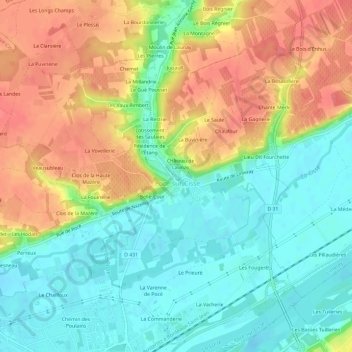
Name: Topografische Karte Clos du Potager, Höhe, Relief.
Durchschnittliche Höhe: 80 m
Minimale Höhe: 51 m
Maximale Höhe: 117 m
Andere topografische Karten
Klicken Sie auf eine Karte, um ihre Topografie, ihre Höhe und ihr Relief anzuzeigen.
Résidence du Lavoir
France > Centre-Val de Loire > Indre-et-Loire > Pocé-sur-Cisse
Résidence du Lavoir, Pocé-sur-Cisse, Loches, Indre-et-Loire, Centre-Val de Loire, France métropolitaine, 37530, France
Durchschnittliche Höhe: 80 m
Les Fougerêts
France > Centre-Val de Loire > Indre-et-Loire > Pocé-sur-Cisse
Les Fougerêts, Pocé-sur-Cisse, Loches, Indre-et-Loire, Centre-Val de Loire, France métropolitaine, 37530, France
Durchschnittliche Höhe: 71 m
Les Passages de Poce
France > Centre-Val de Loire > Indre-et-Loire > Pocé-sur-Cisse
Les Passages de Poce, Pocé-sur-Cisse, Loches, Indre-et-Loire, Centre-Val de Loire, France métropolitaine, 37530, France
Durchschnittliche Höhe: 77 m
Château de Launay
France > Centre-Val de Loire > Indre-et-Loire > Pocé-sur-Cisse > Château de Launay
Château de Launay, Pocé-sur-Cisse, Loches, Indre-et-Loire, Centre-Val de Loire, France métropolitaine, 37530, France
Durchschnittliche Höhe: 81 m
Les Bondes
France > Centre-Val de Loire > Indre-et-Loire > Pocé-sur-Cisse
Les Bondes, Pocé-sur-Cisse, Loches, Indre-et-Loire, Centre-Val de Loire, France métropolitaine, 37530, France
Durchschnittliche Höhe: 84 m