
Topografische Karte Benton County
Interaktive Karte
Klicken Sie auf die Karte, um die Höhe anzuzeigen.
Über diese Karte
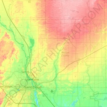
Name: Topografische Karte Benton County, Höhe, Relief.
Ort: Benton County, Minnesota, USA (45.55911 -94.35320 45.82417 -93.75867)
Durchschnittliche Höhe: 340 m
Minimale Höhe: 289 m
Maximale Höhe: 407 m
Andere topografische Karten
Klicken Sie auf eine Karte, um ihre Topografie, ihre Höhe und ihr Relief anzuzeigen.
Alexandria
USA > Minnesota > Alexandria
Alexandria, Douglas County, Minnesota, 56308, USA
Durchschnittliche Höhe: 426 m
Lake of the Woods County
Lake of the Woods County, Minnesota, USA
Durchschnittliche Höhe: 343 m
Prospect Park - East River Road
USA > Minnesota > Minneapolis
Prospect Park - East River Road, Minneapolis, Hennepin County, Minnesota, USA
Durchschnittliche Höhe: 260 m