
Topografische Karte Ober Gabelhorn
Interaktive Karte
Klicken Sie auf die Karte, um die Höhe anzuzeigen.
Über diese Karte
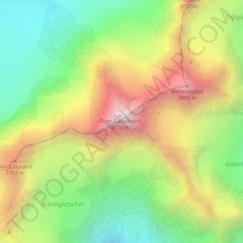
Name: Topografische Karte Ober Gabelhorn, Höhe, Relief.
Ort: Ober Gabelhorn, Zermatt, Visp, Valais/Wallis, 3920, Switzerland (46.03799 7.66755 46.03809 7.66765)
Durchschnittliche Höhe: 3.320 m
Minimale Höhe: 2.744 m
Maximale Höhe: 4.056 m
Andere topografische Karten
Klicken Sie auf eine Karte, um ihre Topografie, ihre Höhe und ihr Relief anzuzeigen.
Pennine Alps
Switzerland > Valais/Wallis > Zermatt
Pennine Alps, Zermatt, Visp, Valais/Wallis, 3920, Switzerland
Durchschnittliche Höhe: 3.842 m
Zumsteinspitze
Switzerland > Valais/Wallis > Zermatt
Zumsteinspitze, Zermatt, Visp, Valais/Wallis, 3920, Switzerland
Durchschnittliche Höhe: 4.001 m
Dunantspitze
Switzerland > Valais/Wallis > Zermatt
Dunantspitze, Zermatt, Visp, Valais/Wallis, 3920, Switzerland
Durchschnittliche Höhe: 4.017 m
Gornergrat
Switzerland > Valais/Wallis > Zermatt
Gornergrat, Hohtälli, Ze Seewjinen, Zermatt, Visp, Valais/Wallis, 3920, Switzerland
Durchschnittliche Höhe: 2.768 m
Dufourspitze (Monte Rosa)
Switzerland > Valais/Wallis > Zermatt
Dufourspitze (Monte Rosa), Zermatt, Visp, Valais/Wallis, 3920, Switzerland
Durchschnittliche Höhe: 4.033 m
Matterhorn
Switzerland > Valais/Wallis > Zermatt
Matterhorn, Zermatt, Visp, Valais/Wallis, 3920, Switzerland
Durchschnittliche Höhe: 3.296 m
Klein Matterhorn
Switzerland > Valais/Wallis > Zermatt
Klein Matterhorn, Zermatt, Visp, Valais/Wallis, 3920, Switzerland
Durchschnittliche Höhe: 3.515 m