
Spenden
Rüsten Sie sich für Ihr nächstes Abenteuer:
Als Amazon-Partner erhält diese Website eine Provision für qualifizierte Käufe, ohne zusätzliche Kosten für Sie.
Topografische Karte Curtis
Klicken Sie auf die Karte, um die Höhe anzuzeigen.
Spenden
Rüsten Sie sich für Ihr nächstes Abenteuer:
Als Amazon-Partner erhält diese Website eine Provision für qualifizierte Käufe, ohne zusätzliche Kosten für Sie.
Über diese Karte
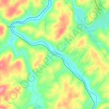
Name: Topografische Karte Curtis, Höhe, Relief.
Ort: Curtis, Fannin County, Georgia, United States (34.90564 -84.35575 34.94564 -84.31575)
Durchschnittliche Höhe: 503 m
Minimale Höhe: 452 m
Maximale Höhe: 569 m
Spenden
Rüsten Sie sich für Ihr nächstes Abenteuer:
Als Amazon-Partner erhält diese Website eine Provision für qualifizierte Käufe, ohne zusätzliche Kosten für Sie.
Andere topografische Karten
Klicken Sie auf eine Karte, um ihre Topografie, ihre Höhe und ihr Relief anzuzeigen.
Blue Ridge
United States > Georgia > Fannin County
Blue Ridge, situated in Fannin County, Georgia, lies within the rugged terrain of the southern Appalachian Mountains. The town itself is at an elevation of approximately 1,762 feet (537 meters) above sea level. The surrounding landscape is characterized by a series of ridges and valleys, with elevations…
Durchschnittliche Höhe: 535 m
McCaysville
United States > Georgia > Fannin County
McCaysville's weather is temperate due to its elevation and location in the southern Appalachians. Summers are warm with average highs in the middle 80s and lows in the lower 60s. Winters are cool with average highs in the 40s and average lows in the 20s. Rainfall is abundant with the yearly average…
Durchschnittliche Höhe: 484 m
Spenden
Rüsten Sie sich für Ihr nächstes Abenteuer:
Als Amazon-Partner erhält diese Website eine Provision für qualifizierte Käufe, ohne zusätzliche Kosten für Sie.
Morgantown Baptist Association Dam
United States > Georgia > Fannin County
Durchschnittliche Höhe: 650 m
Spenden
Rüsten Sie sich für Ihr nächstes Abenteuer:
Als Amazon-Partner erhält diese Website eine Provision für qualifizierte Käufe, ohne zusätzliche Kosten für Sie.