
Spenden
Rüsten Sie sich für Ihr nächstes Abenteuer:
Als Amazon-Partner erhält diese Website eine Provision für qualifizierte Käufe, ohne zusätzliche Kosten für Sie.
Topografische Karte Mission Canyon
Klicken Sie auf die Karte, um die Höhe anzuzeigen.
Spenden
Rüsten Sie sich für Ihr nächstes Abenteuer:
Als Amazon-Partner erhält diese Website eine Provision für qualifizierte Käufe, ohne zusätzliche Kosten für Sie.
Mission Canyon
The approximate center of Mission Canyon is located at 34°26′59″N 119°42′59″W / 34.44972°N 119.71639°W / 34.44972; -119.71639 (34.449797, -119.716315). Situated along the southern facing slopes of the Santa Ynez Mountains, Mission Canyon measures some 1,122 acres comprising an estimated 1,141 parcels primarily consisting of single-family residential development, recreational, open space, and agricultural land uses; but however lacks any commercial or industrial development. Non residential features include the Santa Barbara Botanic Garden, Rocky Nook County Park, the Santa Barbara Woman's Club, and the Santa Barbara County Fire Department Fire Station 15. The topography of the neighborhood varies from relatively flat areas located south of Foothill Road to greater slopes north of Foothill Road, ranging in elevations from approximately 300 ft (91 m) to just over 1,000 ft (305 m) above sea level.
Spenden
Rüsten Sie sich für Ihr nächstes Abenteuer:
Als Amazon-Partner erhält diese Website eine Provision für qualifizierte Käufe, ohne zusätzliche Kosten für Sie.
Über diese Karte
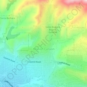
Name: Topografische Karte Mission Canyon, Höhe, Relief.
Durchschnittliche Höhe: 199 m
Minimale Höhe: 69 m
Maximale Höhe: 458 m
Spenden
Rüsten Sie sich für Ihr nächstes Abenteuer:
Als Amazon-Partner erhält diese Website eine Provision für qualifizierte Käufe, ohne zusätzliche Kosten für Sie.
Andere topografische Karten
Klicken Sie auf eine Karte, um ihre Topografie, ihre Höhe und ihr Relief anzuzeigen.
Vandenberg Village
United States > California > Santa Barbara County > Lompoc
Durchschnittliche Höhe: 132 m
Spenden
Rüsten Sie sich für Ihr nächstes Abenteuer:
Als Amazon-Partner erhält diese Website eine Provision für qualifizierte Käufe, ohne zusätzliche Kosten für Sie.
Spenden
Rüsten Sie sich für Ihr nächstes Abenteuer:
Als Amazon-Partner erhält diese Website eine Provision für qualifizierte Käufe, ohne zusätzliche Kosten für Sie.
North Santa Maria
United States > California > Santa Barbara County > Santa Maria
Durchschnittliche Höhe: 65 m
Shoreline Park
United States > California > Santa Barbara County > Santa Barbara
Durchschnittliche Höhe: 21 m
Jalama Beach County Park
United States > California > Santa Barbara County > Jalama
Durchschnittliche Höhe: 40 m
Spenden
Rüsten Sie sich für Ihr nächstes Abenteuer:
Als Amazon-Partner erhält diese Website eine Provision für qualifizierte Käufe, ohne zusätzliche Kosten für Sie.
West Beach
United States > California > Santa Barbara County > Santa Barbara
Durchschnittliche Höhe: 8 m
Haskell's Beach
United States > California > Santa Barbara County > Goleta
Durchschnittliche Höhe: 15 m
Spenden
Rüsten Sie sich für Ihr nächstes Abenteuer:
Als Amazon-Partner erhält diese Website eine Provision für qualifizierte Käufe, ohne zusätzliche Kosten für Sie.
Spenden
Rüsten Sie sich für Ihr nächstes Abenteuer:
Als Amazon-Partner erhält diese Website eine Provision für qualifizierte Käufe, ohne zusätzliche Kosten für Sie.
Toro Canyon
United States > California > Santa Barbara County > Toro Canyon
Durchschnittliche Höhe: 83 m
Spenden
Rüsten Sie sich für Ihr nächstes Abenteuer:
Als Amazon-Partner erhält diese Website eine Provision für qualifizierte Käufe, ohne zusätzliche Kosten für Sie.
Santa Maria
United States > California > Santa Barbara County > Santa Maria
Durchschnittliche Höhe: 185 m
Las Positas Meadows
United States > California > Santa Barbara County > Santa Barbara
Durchschnittliche Höhe: 66 m