
Spenden
Rüsten Sie sich für Ihr nächstes Abenteuer:
Als Amazon-Partner erhält diese Website eine Provision für qualifizierte Käufe, ohne zusätzliche Kosten für Sie.
Topografische Karte Signal d'Ecouves
Klicken Sie auf die Karte, um die Höhe anzuzeigen.
Spenden
Rüsten Sie sich für Ihr nächstes Abenteuer:
Als Amazon-Partner erhält diese Website eine Provision für qualifizierte Käufe, ohne zusätzliche Kosten für Sie.
Über diese Karte
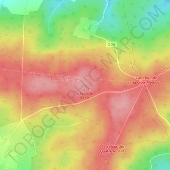
Name: Topografische Karte Signal d'Ecouves, Höhe, Relief.
Durchschnittliche Höhe: 365 m
Minimale Höhe: 294 m
Maximale Höhe: 412 m
Spenden
Rüsten Sie sich für Ihr nächstes Abenteuer:
Als Amazon-Partner erhält diese Website eine Provision für qualifizierte Käufe, ohne zusätzliche Kosten für Sie.
Andere topografische Karten
Klicken Sie auf eine Karte, um ihre Topografie, ihre Höhe und ihr Relief anzuzeigen.
Fontenai-les-Louvets
France > Normandie > Orne > L'Orée-d'Écouves
La commune est traversée par le méridien de Greenwich qui passe notamment par la nef de son église Notre-Dame. Le territoire de la commune est en grande partie situé dans la forêt d'Écouves. Le signal d'Écouves, avec une altitude de 413 mètres, est le point culminant de la région Basse-Normandie.
Durchschnittliche Höhe: 340 m