
Spenden
Rüsten Sie sich für Ihr nächstes Abenteuer:
Als Amazon-Partner erhält diese Website eine Provision für qualifizierte Käufe, ohne zusätzliche Kosten für Sie.
Topografische Karte Creston
Klicken Sie auf die Karte, um die Höhe anzuzeigen.
Spenden
Rüsten Sie sich für Ihr nächstes Abenteuer:
Als Amazon-Partner erhält diese Website eine Provision für qualifizierte Käufe, ohne zusätzliche Kosten für Sie.
Über diese Karte
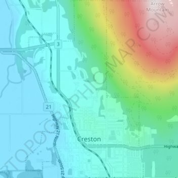
Name: Topografische Karte Creston, Höhe, Relief.
Durchschnittliche Höhe: 738 m
Minimale Höhe: 531 m
Maximale Höhe: 1.496 m
Spenden
Rüsten Sie sich für Ihr nächstes Abenteuer:
Als Amazon-Partner erhält diese Website eine Provision für qualifizierte Käufe, ohne zusätzliche Kosten für Sie.
Andere topografische Karten
Klicken Sie auf eine Karte, um ihre Topografie, ihre Höhe und ihr Relief anzuzeigen.
South Slocan
Canada > British Columbia > Regional District of Central Kootenay > Area H (The Slocan Valley)
Durchschnittliche Höhe: 578 m
Goat River
Canada > British Columbia > Regional District of Central Kootenay > Area B (Goat River Valley)
Durchschnittliche Höhe: 1.713 m
Silent Pass
Canada > British Columbia > Regional District of Central Kootenay > Area D (Lardeau Valley/Duncan Lake)
Durchschnittliche Höhe: 2.100 m
Cooper Creek
Canada > British Columbia > Regional District of Central Kootenay > Area D (Lardeau Valley/Duncan Lake)
Durchschnittliche Höhe: 1.573 m
Spenden
Rüsten Sie sich für Ihr nächstes Abenteuer:
Als Amazon-Partner erhält diese Website eine Provision für qualifizierte Käufe, ohne zusätzliche Kosten für Sie.
Keen Creek
Canada > British Columbia > Regional District of Central Kootenay > Area D (Lardeau Valley/Duncan Lake)
Durchschnittliche Höhe: 976 m
Ymir
Canada > British Columbia > Regional District of Central Kootenay > Area G (Salmo Valley)
Durchschnittliche Höhe: 967 m
Burton (Trout) Creek
Canada > British Columbia > Regional District of Central Kootenay > Area K (The Arrow Lakes)
Durchschnittliche Höhe: 1.659 m
Passmore
Canada > British Columbia > Regional District of Central Kootenay > Area H (The Slocan Valley)
Durchschnittliche Höhe: 819 m
Spenden
Rüsten Sie sich für Ihr nächstes Abenteuer:
Als Amazon-Partner erhält diese Website eine Provision für qualifizierte Käufe, ohne zusätzliche Kosten für Sie.
Winlaw
Canada > British Columbia > Regional District of Central Kootenay > Area H (The Slocan Valley)
Durchschnittliche Höhe: 694 m
Procter
Canada > British Columbia > Regional District of Central Kootenay > Area E (Balfour/Cottonwood Lake)
Durchschnittliche Höhe: 715 m
Shoreacres
Canada > British Columbia > Regional District of Central Kootenay > Area I (Sentinel Mountain)
Durchschnittliche Höhe: 632 m
Kingsgate
Canada > British Columbia > Regional District of Central Kootenay > Area B (Goat River Valley)
Durchschnittliche Höhe: 979 m
Spenden
Rüsten Sie sich für Ihr nächstes Abenteuer:
Als Amazon-Partner erhält diese Website eine Provision für qualifizierte Käufe, ohne zusätzliche Kosten für Sie.
Krestova
Canada > British Columbia > Regional District of Central Kootenay > Area H (The Slocan Valley)
Durchschnittliche Höhe: 640 m
Rockslide Lake
Canada > British Columbia > Regional District of Central Kootenay > Area F (Kokanee Range)
Durchschnittliche Höhe: 1.605 m
Gibson Creek
Canada > British Columbia > Regional District of Central Kootenay > Area I (Sentinel Mountain)
Durchschnittliche Höhe: 778 m
Crawford Bay
Canada > British Columbia > Regional District of Central Kootenay > Area A (Wynndel/Crawford Bay/Riondel)
Durchschnittliche Höhe: 667 m
Spenden
Rüsten Sie sich für Ihr nächstes Abenteuer:
Als Amazon-Partner erhält diese Website eine Provision für qualifizierte Käufe, ohne zusätzliche Kosten für Sie.
Vallican
Canada > British Columbia > Regional District of Central Kootenay > Area H (The Slocan Valley)
Durchschnittliche Höhe: 821 m
Blewett
Canada > British Columbia > Regional District of Central Kootenay > Area E (Balfour/Cottonwood Lake) > Blewett
Durchschnittliche Höhe: 837 m
Ainsworth Hot Springs
Canada > British Columbia > Regional District of Central Kootenay > Area D (Lardeau Valley/Duncan Lake)
Durchschnittliche Höhe: 741 m
Kitchener
Canada > British Columbia > Regional District of Central Kootenay > Area B (Goat River Valley)
Durchschnittliche Höhe: 925 m
Spenden
Rüsten Sie sich für Ihr nächstes Abenteuer:
Als Amazon-Partner erhält diese Website eine Provision für qualifizierte Käufe, ohne zusätzliche Kosten für Sie.
Pass Creek
Canada > British Columbia > Regional District of Central Kootenay > Area I (Sentinel Mountain)
Durchschnittliche Höhe: 751 m
Boswell
Canada > British Columbia > Regional District of Central Kootenay > Area A (Wynndel/Crawford Bay/Riondel)
Durchschnittliche Höhe: 779 m
Stoney Creek
Canada > British Columbia > Regional District of Central Kootenay > Area K (The Arrow Lakes)
Durchschnittliche Höhe: 1.295 m
Taghum
Canada > British Columbia > Regional District of Central Kootenay > Area F (Kokanee Range)
Durchschnittliche Höhe: 745 m
Spenden
Rüsten Sie sich für Ihr nächstes Abenteuer:
Als Amazon-Partner erhält diese Website eine Provision für qualifizierte Käufe, ohne zusätzliche Kosten für Sie.
Poplar Creek
Canada > British Columbia > Regional District of Central Kootenay > Area D (Lardeau Valley/Duncan Lake)
Durchschnittliche Höhe: 1.732 m
Granite
Canada > British Columbia > Regional District of Central Kootenay > Area E (Balfour/Cottonwood Lake) > Blewett
Durchschnittliche Höhe: 772 m
Mount Nemo
Canada > British Columbia > Regional District of Central Kootenay > Area D (Lardeau Valley/Duncan Lake)
Durchschnittliche Höhe: 2.283 m
Salmo
Canada > British Columbia > Regional District of Central Kootenay
Durchschnittliche Höhe: 1.049 m
Spenden
Rüsten Sie sich für Ihr nächstes Abenteuer:
Als Amazon-Partner erhält diese Website eine Provision für qualifizierte Käufe, ohne zusätzliche Kosten für Sie.
Nelway
Canada > British Columbia > Regional District of Central Kootenay > Area G (Salmo Valley)
Durchschnittliche Höhe: 924 m
Sandon
Canada > British Columbia > Regional District of Central Kootenay > Area H (The Slocan Valley)
Durchschnittliche Höhe: 1.529 m
Riondel
Canada > British Columbia > Regional District of Central Kootenay > Area A (Wynndel/Crawford Bay/Riondel)
Durchschnittliche Höhe: 675 m
Harrop
Canada > British Columbia > Regional District of Central Kootenay > Area E (Balfour/Cottonwood Lake)
Durchschnittliche Höhe: 675 m
Spenden
Rüsten Sie sich für Ihr nächstes Abenteuer:
Als Amazon-Partner erhält diese Website eine Provision für qualifizierte Käufe, ohne zusätzliche Kosten für Sie.
Raspberry
Canada > British Columbia > Regional District of Central Kootenay > Area J (Lower Arrow/Columbia)
Durchschnittliche Höhe: 651 m
Butters Lake
Canada > British Columbia > Regional District of Central Kootenay > Area D (Lardeau Valley/Duncan Lake)
Durchschnittliche Höhe: 2.133 m
Crescent Valley
Canada > British Columbia > Regional District of Central Kootenay > Area H (The Slocan Valley)
Durchschnittliche Höhe: 602 m
Mazinaw Mountain
Canada > British Columbia > Regional District of Central Kootenay > Area D (Lardeau Valley/Duncan Lake)
Durchschnittliche Höhe: 2.578 m
Spenden
Rüsten Sie sich für Ihr nächstes Abenteuer:
Als Amazon-Partner erhält diese Website eine Provision für qualifizierte Käufe, ohne zusätzliche Kosten für Sie.
Lemon Creek
Canada > British Columbia > Regional District of Central Kootenay > Area H (The Slocan Valley)
Durchschnittliche Höhe: 1.527 m
Playmor Junction
Canada > British Columbia > Regional District of Central Kootenay > Area H (The Slocan Valley) > South Slocan
Durchschnittliche Höhe: 578 m
Goatfell
Canada > British Columbia > Regional District of Central Kootenay > Area B
Durchschnittliche Höhe: 975 m
Kokanee Creek
Canada > British Columbia > Regional District of Central Kootenay > Area E (Balfour/Cottonwood Lake)
Durchschnittliche Höhe: 2.022 m
Spenden
Rüsten Sie sich für Ihr nächstes Abenteuer:
Als Amazon-Partner erhält diese Website eine Provision für qualifizierte Käufe, ohne zusätzliche Kosten für Sie.
Castlegar
Canada > British Columbia > Regional District of Central Kootenay > Castlegar
Durchschnittliche Höhe: 1.207 m
Burton
Canada > British Columbia > Regional District of Central Kootenay > Area K (The Arrow Lakes)
Durchschnittliche Höhe: 578 m
Bentz Peak
Canada > British Columbia > Regional District of Central Kootenay > Area J (Lower Arrow/Columbia)
Durchschnittliche Höhe: 2.037 m
Kootenay Canal
Canada > British Columbia > Regional District of Central Kootenay > Nelson
Durchschnittliche Höhe: 663 m
Spenden
Rüsten Sie sich für Ihr nächstes Abenteuer:
Als Amazon-Partner erhält diese Website eine Provision für qualifizierte Käufe, ohne zusätzliche Kosten für Sie.
Columbia River
Canada > British Columbia > Regional District of Central Kootenay > Castlegar
Durchschnittliche Höhe: 598 m
Erickson
Canada > British Columbia > Regional District of Central Kootenay > Area B (Goat River Valley)
Durchschnittliche Höhe: 680 m
Balfour
Canada > British Columbia > Regional District of Central Kootenay > Area E (Balfour/Cottonwood Lake)
Durchschnittliche Höhe: 673 m
Commonwealth Mountain
Canada > British Columbia > Regional District of Central Kootenay > Area G (Salmo Valley)
Durchschnittliche Höhe: 1.871 m
Spenden
Rüsten Sie sich für Ihr nächstes Abenteuer:
Als Amazon-Partner erhält diese Website eine Provision für qualifizierte Käufe, ohne zusätzliche Kosten für Sie.
Hall Creek
Canada > British Columbia > Regional District of Central Kootenay > Area G (Salmo Valley)
Durchschnittliche Höhe: 1.570 m
Procter
Canada > British Columbia > Regional District of Central Kootenay > Area E (Balfour/Cottonwood Lake)
Durchschnittliche Höhe: 715 m