
Topografische Karte Amance
Interaktive Karte
Klicken Sie auf die Karte, um die Höhe anzuzeigen.
Über diese Karte
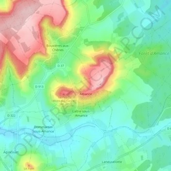
Name: Topografische Karte Amance, Höhe, Relief.
Durchschnittliche Höhe: 271 m
Minimale Höhe: 205 m
Maximale Höhe: 411 m
Andere topografische Karten
Klicken Sie auf eine Karte, um ihre Topografie, ihre Höhe und ihr Relief anzuzeigen.
Toul
France > Grand Est > Meurthe-et-Moselle
Toul, Meurthe-et-Moselle, Grand Est, Metropolitan France, 54200, France
Durchschnittliche Höhe: 245 m
Ville-Houdlémont
France > Grand Est > Meurthe-et-Moselle
Ville-Houdlémont, Val-de-Briey, Meurthe-et-Moselle, Grand Est, Metropolitan France, 54730, France
Durchschnittliche Höhe: 292 m
Nancy
France > Grand Est > Meurthe-et-Moselle
Nancy, Meurthe-et-Moselle, Grand Est, Metropolitan France, France
Durchschnittliche Höhe: 230 m
La Puce
France > Grand Est > Meurthe-et-Moselle > Boismont
La Puce, Boismont, Val-de-Briey, Meurthe-et-Moselle, Grand Est, Metropolitan France, 54620, France
Durchschnittliche Höhe: 286 m
Dommartin-lès-Toul
France > Grand Est > Meurthe-et-Moselle
Dommartin-lès-Toul, Toul, Meurthe-et-Moselle, Grand Est, Metropolitan France, 54200, France
Durchschnittliche Höhe: 228 m
Briey
France > Grand Est > Meurthe-et-Moselle > Val de Briey
Briey, Val de Briey, Val-de-Briey, Meurthe-et-Moselle, Grand Est, Metropolitan France, 54150, France
Durchschnittliche Höhe: 262 m
Longwy
France > Grand Est > Meurthe-et-Moselle
Longwy, Val-de-Briey, Meurthe-et-Moselle, Grand Est, Metropolitan France, 54400, France
Durchschnittliche Höhe: 332 m
Agincourt
France > Grand Est > Meurthe-et-Moselle
Agincourt, Nancy, Meurthe-et-Moselle, Grand Est, Metropolitan France, 54770, France
Durchschnittliche Höhe: 259 m
Custines
France > Grand Est > Meurthe-et-Moselle
Custines, Nancy, Meurthe-et-Moselle, Grand Est, Metropolitan France, 54670, France
Durchschnittliche Höhe: 275 m
Baccarat
France > Grand Est > Meurthe-et-Moselle
Baccarat, Lunéville, Meurthe-et-Moselle, Grand Est, Metropolitan France, 54120, France
Durchschnittliche Höhe: 304 m
Pont-à-Mousson
France > Grand Est > Meurthe-et-Moselle
Pont-à-Mousson, Nancy, Meurthe-et-Moselle, Grand Est, Metropolitan France, 54700, France
Durchschnittliche Höhe: 234 m
Pannes
France > Grand Est > Meurthe-et-Moselle
Pannes, Toul, Meurthe-et-Moselle, Grand Est, Metropolitan France, 54470, France
Durchschnittliche Höhe: 235 m
Vandœuvre-lès-Nancy
France > Grand Est > Meurthe-et-Moselle
Vandœuvre-lès-Nancy, Nancy, Meurthe-et-Moselle, Grand Est, Metropolitan France, 54500, France
Durchschnittliche Höhe: 273 m
Saint-Martin
France > Grand Est > Meurthe-et-Moselle
Saint-Martin, Lunéville, Meurthe-et-Moselle, Grand Est, Metropolitan France, 54450, France
Durchschnittliche Höhe: 262 m
Saint-Firmin
France > Grand Est > Meurthe-et-Moselle
Saint-Firmin, Nancy, Meurthe-et-Moselle, Grand Est, Metropolitan France, 54930, France
Durchschnittliche Höhe: 296 m
Villerupt
France > Grand Est > Meurthe-et-Moselle > Villerupt
Villerupt, Briey, Meurthe-et-Moselle, Grand Est, Metropolitan France, 54190, France
Durchschnittliche Höhe: 386 m
Montauville
France > Grand Est > Meurthe-et-Moselle > Montauville
Montauville, Nancy, Meurthe-et-Moselle, Grand Est, Metropolitan France, 54700, France
Durchschnittliche Höhe: 271 m
Chevreuil
France > Grand Est > Meurthe-et-Moselle > Valleroy
Chevreuil, Valleroy, Briey, Meurthe-et-Moselle, Grand Est, Metropolitan France, 54910, France
Durchschnittliche Höhe: 216 m
Serres
France > Grand Est > Meurthe-et-Moselle
Serres, Lunéville, Meurthe-et-Moselle, Grand Est, Metropolitan France, 54370, France
Durchschnittliche Höhe: 272 m
Pompey
France > Grand Est > Meurthe-et-Moselle > Pompey
Pompey, Nancy, Meurthe-et-Moselle, Grand Est, Metropolitan France, 54340, France
Durchschnittliche Höhe: 254 m
Belleville
France > Grand Est > Meurthe-et-Moselle
Belleville, Nancy, Meurthe-et-Moselle, Grand Est, Metropolitan France, 54940, France
Durchschnittliche Höhe: 236 m
Malzéville
France > Grand Est > Meurthe-et-Moselle > Malzéville
Malzéville, Nancy, Meurthe-et-Moselle, Grand Est, Metropolitan France, 54220, France
Durchschnittliche Höhe: 258 m