
Topografische Karte Presidio County
Interaktive Karte
Klicken Sie auf die Karte, um die Höhe anzuzeigen.
Über diese Karte
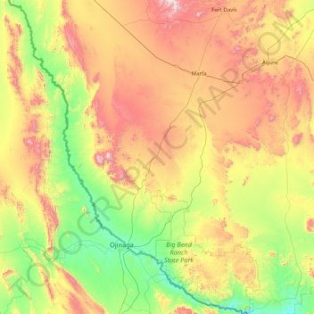
Name: Topografische Karte Presidio County, Höhe, Relief.
Ort: Presidio County, Texas, United States of America (29.25837 -104.98075 30.62940 -103.79246)
Durchschnittliche Höhe: 1.255 m
Minimale Höhe: 716 m
Maximale Höhe: 2.348 m
Geographically, Presidio County comprises 3,857 square miles (9,990 km2) of contrasting topography, geology, and vegetation. In the north and west, clay and sandy loam cover the rolling plains known as the Marfa Plateau and the Highland Country, providing good ranges of grama grasses for the widely acclaimed Highland Herefords. In the central, far western, and southeastern areas of the county, some of the highest mountain ranges in Texas are found. These peaks are formed of volcanic rock and covered with loose surface rubble. They support desert shrubs and cacti and dominate a landscape of rugged canyons and numerous springs. The spring-fed Capote Falls, with a drop of 175 feet (53 m), the highest in Texas, is located in western Presidio County. In the southern and western parts of the county, the volcanic cliffs of the Candelaria Rimrock (also called the Sierra Vieja) rise perpendicular and run parallel to the river, separating the highland prairies from the desert floor hundreds of feet below them. The gravel pediment, which allows only the growth of desert shrubs and cacti, extends from the Rimrock to the flood plain of the river. Along the river, irrigation allows the farming of vegetables, grains, and cotton. No permanent streams exist in the county, although many arroyos become raging torrents during heavy rainfalls. Major ones are Alamito Creek, Cibolo Creek, Capote Creek, and Pinto Canyon. San Esteban Dam was built across Alamito Creek and on the site of a historic spring-fed tinaja in 1911 as an irrigation and land-promotion project. Altitudes in the county vary from 2,518 to 7,728 feet (767 to 2,355 m) above sea level. Temperatures, moderated by the mountains, vary from 33 °F (1 °C) in January to 100 °F (38 °C) in July. Average rainfall is 12 inches (300 mm) per year, mainly in June, July, and August. The growing season extends for 238 days. Natural resources under production in 1982 were perlite, crushed rhyolite, sand, and gravel. Silver mining contributed greatly to the economy of the county from the 1880s to the 1940s. Presidio County has no oil or gas production.
Andere topografische Karten
Klicken Sie auf eine Karte, um ihre Topografie, ihre Höhe und ihr Relief anzuzeigen.
Medina County
United States of America > Texas
Medina County, Texas, United States of America
Durchschnittliche Höhe: 314 m
Kerrville
United States of America > Texas > Kerrville
Kerrville, Kerr County, Texas, United States of America
Durchschnittliche Höhe: 545 m
Washington County
United States of America > Texas
Washington County, Texas, United States of America
Durchschnittliche Höhe: 87 m
Cherokee County
United States of America > Texas
Cherokee County, Texas, United States of America
Durchschnittliche Höhe: 118 m
Marion County
United States of America > Texas
Marion County, Texas, 75657, United States of America
Durchschnittliche Höhe: 87 m
Blum
United States of America > Texas > Blum
Blum, Hill County, Texas, United States of America
Durchschnittliche Höhe: 190 m
Jackson County
United States of America > Texas
Jackson County, Texas, United States of America
Durchschnittliche Höhe: 22 m
Bastrop County
United States of America > Texas
Bastrop County, Texas, United States of America
Durchschnittliche Höhe: 143 m
KLBK-TV (Lubbock)
United States of America > Texas > Lubbock
KLBK-TV (Lubbock), 74th Street, South Lubbock, Lubbock, Texas, 79423, United States of America
Durchschnittliche Höhe: 985 m
Murphy
United States of America > Texas > Murphy
Murphy, Collin County, Texas, 75094, United States of America
Durchschnittliche Höhe: 169 m
Duval County
United States of America > Texas
Duval County, Texas, United States of America
Durchschnittliche Höhe: 144 m
Joshua
United States of America > Texas > Joshua
Joshua, Johnson County, Texas, 76058, United States of America
Durchschnittliche Höhe: 269 m
Upton County
United States of America > Texas
Upton County, Texas, United States of America
Durchschnittliche Höhe: 825 m
Delta County
United States of America > Texas
Delta County, Texas, United States of America
Durchschnittliche Höhe: 148 m
Franklin County
United States of America > Texas
Franklin County, Texas, United States of America
Durchschnittliche Höhe: 126 m
Pecos County
United States of America > Texas
Pecos County, Texas, United States of America
Durchschnittliche Höhe: 969 m
Fredericksburg
United States of America > Texas > Fredericksburg
Fredericksburg, Gillespie County, Texas, 78624, United States of America
Durchschnittliche Höhe: 526 m
Wheeler County
United States of America > Texas
Wheeler County, Texas, United States of America
Durchschnittliche Höhe: 747 m
Kent County
United States of America > Texas
Kent County, Texas, United States of America
Durchschnittliche Höhe: 646 m
Madison County
United States of America > Texas
Madison County, Texas, United States of America
Durchschnittliche Höhe: 91 m
Grayson County
United States of America > Texas
Grayson County, Texas, United States of America
Durchschnittliche Höhe: 214 m
Starr County
United States of America > Texas
Starr County, Texas, United States of America
Durchschnittliche Höhe: 98 m
Henderson County
United States of America > Texas
Henderson County, Texas, United States of America
Durchschnittliche Höhe: 127 m
Hamilton County
United States of America > Texas
Hamilton County, Texas, United States of America
Durchschnittliche Höhe: 337 m
Clay County
United States of America > Texas
Clay County, Texas, United States of America
Durchschnittliche Höhe: 295 m
El Paso County
United States of America > Texas
El Paso County, Texas, United States of America
Durchschnittliche Höhe: 1.267 m
Kenedy County
United States of America > Texas
Kenedy County, Texas, 78385, United States of America
Durchschnittliche Höhe: 12 m
Shelby County
United States of America > Texas
Shelby County, Texas, United States of America
Durchschnittliche Höhe: 89 m
Lockhart
United States of America > Texas > Lockhart
Lockhart, Caldwell County, Texas, 78644, United States of America
Durchschnittliche Höhe: 156 m
Midland County
United States of America > Texas
Midland County, Texas, United States of America
Durchschnittliche Höhe: 842 m
King County
United States of America > Texas
King County, Texas, 79236, United States of America
Durchschnittliche Höhe: 540 m
Kerr County
United States of America > Texas
Kerr County, Texas, United States of America
Durchschnittliche Höhe: 607 m
Travis County
United States of America > Texas
Travis County, Texas, United States of America
Durchschnittliche Höhe: 231 m
Karnes County
United States of America > Texas
Karnes County, Texas, United States of America
Durchschnittliche Höhe: 114 m
Culberson County
United States of America > Texas
Culberson County, Texas, United States of America
Durchschnittliche Höhe: 1.253 m
Midland
United States of America > Texas > Midland
Midland, Midland County, Texas, United States of America
Durchschnittliche Höhe: 855 m
Collin County
United States of America > Texas
Collin County, Texas, United States of America
Durchschnittliche Höhe: 191 m
Andrews County
United States of America > Texas
Andrews County, Texas, 79714, United States of America
Durchschnittliche Höhe: 965 m
Reeves County
United States of America > Texas
Reeves County, Texas, United States of America
Durchschnittliche Höhe: 986 m
Rio Grande City
United States of America > Texas > Rio Grande City
Rio Grande City, Starr County, Texas, United States of America
Durchschnittliche Höhe: 63 m