
Topografische Karte Almagro
Interaktive Karte
Klicken Sie auf die Karte, um die Höhe anzuzeigen.
Über diese Karte
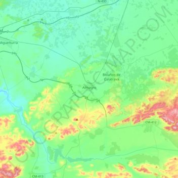
Name: Topografische Karte Almagro, Höhe, Relief.
Durchschnittliche Höhe: 666 m
Minimale Höhe: 595 m
Maximale Höhe: 921 m
Andere topografische Karten
Klicken Sie auf eine Karte, um ihre Topografie, ihre Höhe und ihr Relief anzuzeigen.
Monte Cayo
España > Castilla-La Mancha > Campo de Calatrava > Almagro
Monte Cayo, Almagro, Campo de Calatrava, Ciudad Real, Castilla-La Mancha, España
Durchschnittliche Höhe: 633 m
Aldea del Rey
España > Castilla-La Mancha > Campo de Calatrava
Aldea del Rey, Campo de Calatrava, Ciudad Real, Castilla-La Mancha, España
Durchschnittliche Höhe: 738 m