
Topografische Karte Bude
Interaktive Karte
Klicken Sie auf die Karte, um die Höhe anzuzeigen.
Bude
Its earlier importance was as a harbour, and then a source of sea sand useful for improving the inland soil. This was transported on the Bude Canal. The Victorians favoured it as a seaside resort. With new rail links, it became a popular seaside destination in the 20th century. Bradshaw's Guide of 1866, Section 2, described Bude as: "a small port and picturesque village in the north-eastern extremity of Cornwall". It described the town as having the dignity of a fashionable marine resort with excellent facilities for bathers. The harbour bed consists of fine bright yellow sand consisting of small shells. "The sea view is of a striking, bold and sublime description – the rocks rising on every side to lofty broken elevations". It also describes Bude as a romantic retreat.
Über diese Karte
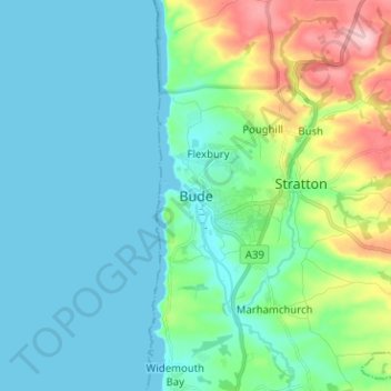
Name: Topografische Karte Bude, Höhe, Relief.
Ort: Bude, Cornwall, England, EX23 8LD, United Kingdom (50.78853 -4.58694 50.86853 -4.50694)
Durchschnittliche Höhe: 39 m
Minimale Höhe: 0 m
Maximale Höhe: 181 m
Andere topografische Karten
Klicken Sie auf eine Karte, um ihre Topografie, ihre Höhe und ihr Relief anzuzeigen.