Geolokalisieren

Topografische Karte Stosswihr

Interaktive Karte

Klicken Sie auf die Karte, um die Höhe anzuzeigen.

Über diese Karte

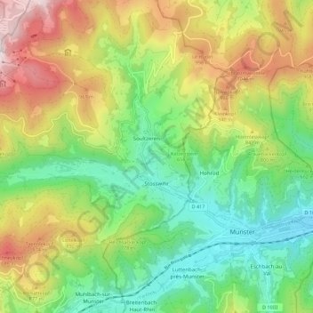
Name: Topografische Karte Stosswihr, Höhe, Relief.

Ort: Stosswihr, Colmar-Ribeauvillé, Haut-Rhin, Grand Est, France métropolitaine, 68140, France (48.03415 7.00966 48.08302 7.11982)

Durchschnittliche Höhe: 708 m

Minimale Höhe: 349 m

Maximale Höhe: 1.281 m

Andere topografische Karten

Klicken Sie auf eine Karte, um ihre Topografie, ihre Höhe und ihr Relief anzuzeigen.

Jebsheim

France > Grand Est > Haut-Rhin

Jebsheim, Colmar-Ribeauvillé, Haut-Rhin, Grand Est, France métropolitaine, 68320, France

Durchschnittliche Höhe: 182 m

Steinbach

France > Grand Est > Haut-Rhin

Steinbach, Thann-Guebwiller, Haut-Rhin, Grand Est, France métropolitaine, 68700, France

Durchschnittliche Höhe: 441 m

Munster

France > Grand Est > Haut-Rhin

Munster, Colmar-Ribeauvillé, Haut-Rhin, Grand Est, France métropolitaine, 68140, France

Durchschnittliche Höhe: 529 m

Folgensbourg

France > Grand Est > Haut-Rhin > Folgensbourg

Folgensbourg, Mulhouse, Haut-Rhin, Grand Est, France métropolitaine, 68220, France

Durchschnittliche Höhe: 439 m

Mittlach

France > Grand Est > Haut-Rhin

Mittlach, Colmar-Ribeauvillé, Haut-Rhin, Grand Est, France métropolitaine, 68380, France

Durchschnittliche Höhe: 862 m

Kembs

France > Grand Est > Haut-Rhin

Kembs, Mulhouse, Haut-Rhin, Grand Est, France métropolitaine, 68680, France

Durchschnittliche Höhe: 263 m