
Spenden
Rüsten Sie sich für Ihr nächstes Abenteuer:
Als Amazon-Partner erhält diese Website eine Provision für qualifizierte Käufe, ohne zusätzliche Kosten für Sie.
Topografische Karte Baddesley Ensor
Klicken Sie auf die Karte, um die Höhe anzuzeigen.
Spenden
Rüsten Sie sich für Ihr nächstes Abenteuer:
Als Amazon-Partner erhält diese Website eine Provision für qualifizierte Käufe, ohne zusätzliche Kosten für Sie.
Über diese Karte
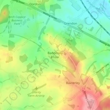
Name: Topografische Karte Baddesley Ensor, Höhe, Relief.
Durchschnittliche Höhe: 111 m
Minimale Höhe: 64 m
Maximale Höhe: 182 m
Spenden
Rüsten Sie sich für Ihr nächstes Abenteuer:
Als Amazon-Partner erhält diese Website eine Provision für qualifizierte Käufe, ohne zusätzliche Kosten für Sie.
Andere topografische Karten
Klicken Sie auf eine Karte, um ihre Topografie, ihre Höhe und ihr Relief anzuzeigen.
Newton Regis CP
United Kingdom > England > Warwickshire > North Warwickshire
Durchschnittliche Höhe: 85 m
Water Orton CP
United Kingdom > England > Warwickshire > North Warwickshire
Durchschnittliche Höhe: 84 m
Spenden
Rüsten Sie sich für Ihr nächstes Abenteuer:
Als Amazon-Partner erhält diese Website eine Provision für qualifizierte Käufe, ohne zusätzliche Kosten für Sie.
Hartshill Hayes Country Park
United Kingdom > England > Warwickshire > North Warwickshire > Ansley Common
Durchschnittliche Höhe: 127 m
Merevale Lake
United Kingdom > England > Warwickshire > North Warwickshire > Atherstone
Durchschnittliche Höhe: 119 m
Spenden
Rüsten Sie sich für Ihr nächstes Abenteuer:
Als Amazon-Partner erhält diese Website eine Provision für qualifizierte Käufe, ohne zusätzliche Kosten für Sie.
Baxterley CP
United Kingdom > England > Warwickshire > North Warwickshire
Durchschnittliche Höhe: 135 m
River Bourne
United Kingdom > England > Warwickshire > North Warwickshire
Durchschnittliche Höhe: 122 m
Coleshill CP
United Kingdom > England > Warwickshire > North Warwickshire
Durchschnittliche Höhe: 86 m
Hartshill CP
United Kingdom > England > Warwickshire > North Warwickshire
Durchschnittliche Höhe: 113 m
Spenden
Rüsten Sie sich für Ihr nächstes Abenteuer:
Als Amazon-Partner erhält diese Website eine Provision für qualifizierte Käufe, ohne zusätzliche Kosten für Sie.
Holbech's Wood
United Kingdom > England > Warwickshire > North Warwickshire > Fillongley CP
Durchschnittliche Höhe: 140 m
Hoar Park
United Kingdom > England > Warwickshire > North Warwickshire > Bentley CP
Durchschnittliche Höhe: 135 m
Spenden
Rüsten Sie sich für Ihr nächstes Abenteuer:
Als Amazon-Partner erhält diese Website eine Provision für qualifizierte Käufe, ohne zusätzliche Kosten für Sie.
Fillongley CP
United Kingdom > England > Warwickshire > North Warwickshire
Durchschnittliche Höhe: 142 m
Pooley Country Park
United Kingdom > England > Warwickshire > North Warwickshire > Polesworth
Durchschnittliche Höhe: 76 m
Lea Marston Purification Lakes
United Kingdom > England > Warwickshire > North Warwickshire > Marston
Durchschnittliche Höhe: 70 m
Spenden
Rüsten Sie sich für Ihr nächstes Abenteuer:
Als Amazon-Partner erhält diese Website eine Provision für qualifizierte Käufe, ohne zusätzliche Kosten für Sie.
Mancetter CP
United Kingdom > England > Warwickshire > North Warwickshire
Durchschnittliche Höhe: 112 m
Middleton CP
United Kingdom > England > Warwickshire > North Warwickshire
Durchschnittliche Höhe: 89 m
Spenden
Rüsten Sie sich für Ihr nächstes Abenteuer:
Als Amazon-Partner erhält diese Website eine Provision für qualifizierte Käufe, ohne zusätzliche Kosten für Sie.
Middleton CP
United Kingdom > England > Warwickshire > North Warwickshire
Durchschnittliche Höhe: 89 m
Shuttington CP
United Kingdom > England > Warwickshire > North Warwickshire
Durchschnittliche Höhe: 77 m
Water Orton CP
United Kingdom > England > Warwickshire > North Warwickshire
Durchschnittliche Höhe: 84 m
Fillongley CP
United Kingdom > England > Warwickshire > North Warwickshire
Durchschnittliche Höhe: 142 m
Spenden
Rüsten Sie sich für Ihr nächstes Abenteuer:
Als Amazon-Partner erhält diese Website eine Provision für qualifizierte Käufe, ohne zusätzliche Kosten für Sie.
Coleshill CP
United Kingdom > England > Warwickshire > North Warwickshire
Durchschnittliche Höhe: 86 m