
Topografische Karte Lac Bow
Interaktive Karte
Klicken Sie auf die Karte, um die Höhe anzuzeigen.
Über diese Karte
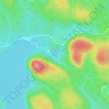
Name: Topografische Karte Lac Bow, Höhe, Relief.
Durchschnittliche Höhe: 389 m
Minimale Höhe: 353 m
Maximale Höhe: 466 m
Andere topografische Karten
Klicken Sie auf eine Karte, um ihre Topografie, ihre Höhe und ihr Relief anzuzeigen.
Lac Cellier
Canada > Québec > La Vallée-de-la-Gatineau > Lac-Pythonga
Lac Cellier, Lac-Pythonga, La Vallée-de-la-Gatineau, Outaouais, Québec, Canada
Durchschnittliche Höhe: 375 m
Lac Grey
Canada > Québec > La Vallée-de-la-Gatineau > Lac-Pythonga
Lac Grey, Lac-Pythonga, La Vallée-de-la-Gatineau, Outaouais, Québec, Canada
Durchschnittliche Höhe: 387 m
Lac Tarse
Canada > Québec > La Vallée-de-la-Gatineau > Lac-Pythonga
Lac Tarse, Lac-Pythonga, La Vallée-de-la-Gatineau, Outaouais, Québec, Canada
Durchschnittliche Höhe: 279 m
Lac Chalain
Canada > Québec > La Vallée-de-la-Gatineau > Lac-Pythonga
Lac Chalain, Lac-Pythonga, La Vallée-de-la-Gatineau, Outaouais, Québec, Canada
Durchschnittliche Höhe: 384 m