
Topografische Karte DeBary
Klicken Sie auf die Karte, um die Höhe anzuzeigen.
Über diese Karte
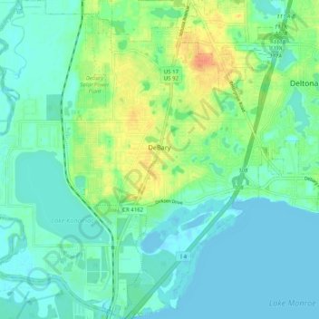
Name: Topografische Karte DeBary, Höhe, Relief.
Ort: DeBary, Volusia County, Florida, 32713, United States (28.83616 -81.36614 28.92320 -81.27520)
Durchschnittliche Höhe: 10 m
Minimale Höhe: -3 m
Maximale Höhe: 37 m
Andere topografische Karten
Klicken Sie auf eine Karte, um ihre Topografie, ihre Höhe und ihr Relief anzuzeigen.
Samsula-Spruce Creek
United States > Florida > Volusia County > New Smyrna Beach > South Village
Durchschnittliche Höhe: 8 m
De Leon Springs
United States > Florida > Volusia County > De Leon Springs
Durchschnittliche Höhe: 17 m
De Leon Springs
United States > Florida > Volusia County > De Leon Springs
Durchschnittliche Höhe: 17 m
De Leon Springs
United States > Florida > Volusia County > De Leon Springs
Durchschnittliche Höhe: 17 m
De Leon Springs
United States > Florida > Volusia County > De Leon Springs
Durchschnittliche Höhe: 17 m
Halifax Estates
United States > Florida > Volusia County > Daytona Beach Shores
Durchschnittliche Höhe: 1 m
Cypress Lake Park
United States > Florida > Volusia County > Cypress Lake Estates
Durchschnittliche Höhe: 22 m