
Spenden
Rüsten Sie sich für Ihr nächstes Abenteuer:
Als Amazon-Partner erhält diese Website eine Provision für qualifizierte Käufe, ohne zusätzliche Kosten für Sie.
Topografische Karte Scenic View
Klicken Sie auf die Karte, um die Höhe anzuzeigen.
Spenden
Rüsten Sie sich für Ihr nächstes Abenteuer:
Als Amazon-Partner erhält diese Website eine Provision für qualifizierte Käufe, ohne zusätzliche Kosten für Sie.
Über diese Karte
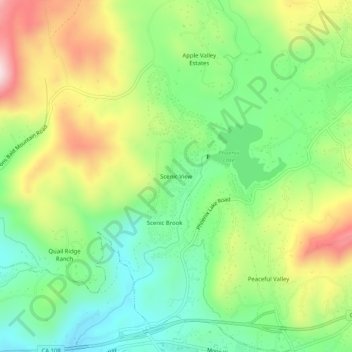
Name: Topografische Karte Scenic View, Höhe, Relief.
Durchschnittliche Höhe: 765 m
Minimale Höhe: 613 m
Maximale Höhe: 998 m
Spenden
Rüsten Sie sich für Ihr nächstes Abenteuer:
Als Amazon-Partner erhält diese Website eine Provision für qualifizierte Käufe, ohne zusätzliche Kosten für Sie.
Andere topografische Karten
Klicken Sie auf eine Karte, um ihre Topografie, ihre Höhe und ihr Relief anzuzeigen.
Sonora
United States > California > Tuolumne County
Sonora is located at 37°59′04″N 120°22′54″W / 37.984361°N 120.381767°W / 37.984361; -120.381767, around the intersection of California State Highways 49 and 108 The altitude is 1,825 feet (556 m). According to the United States Census Bureau, the city has a total area of 3.1 square miles…
Durchschnittliche Höhe: 615 m
Twain Harte
United States > California > Tuolumne County
Twain Harte is situated in Tuolumne County along Highway 108 at an elevation of 3,640 feet (1,110 m).
Durchschnittliche Höhe: 1.123 m
Spenden
Rüsten Sie sich für Ihr nächstes Abenteuer:
Als Amazon-Partner erhält diese Website eine Provision für qualifizierte Käufe, ohne zusätzliche Kosten für Sie.
Lake Don Pedro Swimming Lagoon
United States > California > Tuolumne County
Durchschnittliche Höhe: 252 m
Spenden
Rüsten Sie sich für Ihr nächstes Abenteuer:
Als Amazon-Partner erhält diese Website eine Provision für qualifizierte Käufe, ohne zusätzliche Kosten für Sie.
Sonora
United States > California > Tuolumne County
Sonora is located around the intersection of California State Highways 49 and 108 The altitude is 1,825 feet (556 m). According to the United States Census Bureau, the city covers a total area of 3.2 square miles (8.3 km2), making it the county's largest community by land area. 99.57% of the area is land and…
Durchschnittliche Höhe: 614 m
Spenden
Rüsten Sie sich für Ihr nächstes Abenteuer:
Als Amazon-Partner erhält diese Website eine Provision für qualifizierte Käufe, ohne zusätzliche Kosten für Sie.
Tuolumne Meadows
United States > California > Tuolumne County > Tuolumne Meadows
Durchschnittliche Höhe: 2.668 m
Spenden
Rüsten Sie sich für Ihr nächstes Abenteuer:
Als Amazon-Partner erhält diese Website eine Provision für qualifizierte Käufe, ohne zusätzliche Kosten für Sie.
Sonora
United States > California > Tuolumne County
Sonora is located at 37°59′04″N 120°22′54″W / 37.984361°N 120.381767°W / 37.984361; -120.381767, around the intersection of California State Highways 49 and 108 The altitude is 1,825 feet (556 m). According to the United States Census Bureau, the city has a total area of 3.1 square miles…
Durchschnittliche Höhe: 615 m
Soulsbyville
United States > California > Tuolumne County > Willow Springs
Durchschnittliche Höhe: 911 m
Spenden
Rüsten Sie sich für Ihr nächstes Abenteuer:
Als Amazon-Partner erhält diese Website eine Provision für qualifizierte Käufe, ohne zusätzliche Kosten für Sie.