
Topografische Karte Ruisseau Antostagan
Interaktive Karte
Klicken Sie auf die Karte, um die Höhe anzuzeigen.
Über diese Karte
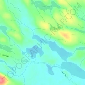
Name: Topografische Karte Ruisseau Antostagan, Höhe, Relief.
Durchschnittliche Höhe: 395 m
Minimale Höhe: 373 m
Maximale Höhe: 454 m
Andere topografische Karten
Klicken Sie auf eine Karte, um ihre Topografie, ihre Höhe und ihr Relief anzuzeigen.
Lac Doolittle
Canada > Québec > La Vallée-de-la-Gatineau > Lac-Pythonga
Lac Doolittle, Lac-Pythonga, La Vallée-de-la-Gatineau, Outaouais, Québec, Canada
Durchschnittliche Höhe: 379 m
Lac Rhéaume
Canada > Québec > La Vallée-de-la-Gatineau > Lac-Pythonga
Lac Rhéaume, Lac-Pythonga, La Vallée-de-la-Gatineau, Outaouais, Québec, Canada
Durchschnittliche Höhe: 296 m
Lac Camatose
Canada > Québec > La Vallée-de-la-Gatineau > Lac-Pythonga
Lac Camatose, Lac-Pythonga, La Vallée-de-la-Gatineau, Outaouais, Québec, Canada
Durchschnittliche Höhe: 365 m
Lac Jean Pere
Canada > Québec > La Vallée-de-la-Gatineau > Lac-Pythonga
Lac Jean Pere, Lac-Pythonga, La Vallée-de-la-Gatineau, Outaouais, Québec, Canada
Durchschnittliche Höhe: 386 m
Lac Camatose
Canada > Québec > La Vallée-de-la-Gatineau > Lac-Pythonga
Lac Camatose, Lac-Pythonga, La Vallée-de-la-Gatineau, Outaouais, Québec, Canada
Durchschnittliche Höhe: 362 m