
Topografische Karte Ferrol
Interaktive Karte
Klicken Sie auf die Karte, um die Höhe anzuzeigen.
Über diese Karte
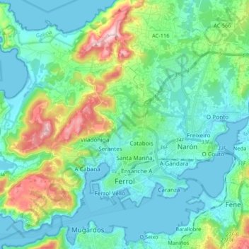
Name: Topografische Karte Ferrol, Höhe, Relief.
Ort: Ferrol, A Corogne, Galice, Espagne (43.45319 -8.34810 43.56930 -8.18606)
Durchschnittliche Höhe: 67 m
Minimale Höhe: -2 m
Maximale Höhe: 301 m
Andere topografische Karten
Klicken Sie auf eine Karte, um ihre Topografie, ihre Höhe und ihr Relief anzuzeigen.
San Román de Doniños
Espagne > Galice > Ferrol > Ferrol
San Román de Doniños, Doniños, Ferrol, A Corogne, Galice, 15593, Espagne
Durchschnittliche Höhe: 143 m
O Carabuchal
Espagne > Galice > Ferrol > Narón
O Carabuchal, Trasancos, Narón, Ferrol, A Corogne, Galice, 15573, Espagne
Durchschnittliche Höhe: 86 m
O Campo do Hospital
Espagne > Galice > Ferrol > Cedeira
O Campo do Hospital, Montoxo, Cedeira, Ferrol, A Corogne, Galice, 15359, Espagne
Durchschnittliche Höhe: 252 m
San Felipe
Espagne > Galice > Ferrol > Ferrol > San Felipe
San Felipe, Brión, Ferrol, A Corogne, Galice, 15591, Espagne
Durchschnittliche Höhe: 92 m