
Topografische Karte Col du Calvaire
Interaktive Karte
Klicken Sie auf die Karte, um die Höhe anzuzeigen.
Über diese Karte
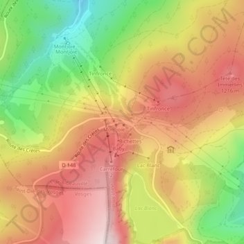
Name: Topografische Karte Col du Calvaire, Höhe, Relief.
Durchschnittliche Höhe: 1.073 m
Minimale Höhe: 828 m
Maximale Höhe: 1.268 m
Andere topografische Karten
Klicken Sie auf eine Karte, um ihre Topografie, ihre Höhe und ihr Relief anzuzeigen.
Col des Bagenelles
France > Grand Est > Le Bonhomme
Col des Bagenelles, D 48, Maison Forestière du Général Bataille, Le Bonhomme, Colmar-Ribeauvillé, Haut-Rhin, Grand Est, France métropolitaine, 68650, France
Durchschnittliche Höhe: 897 m
Col du Bonhomme
France > Grand Est > Le Bonhomme
Col du Bonhomme, D 415, Maison Forestière du Général Bataille, Le Bonhomme, Saint-Dié-des-Vosges, Haut-Rhin, Grand Est, France métropolitaine, 68650, France
Durchschnittliche Höhe: 908 m