
Topografische Karte L'Ardoise
Interaktive Karte
Klicken Sie auf die Karte, um die Höhe anzuzeigen.
Über diese Karte
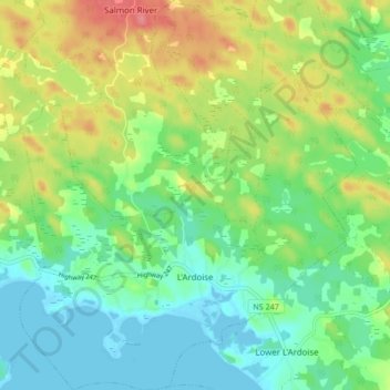
Name: Topografische Karte L'Ardoise, Höhe, Relief.
Durchschnittliche Höhe: 27 m
Minimale Höhe: -2 m
Maximale Höhe: 75 m
Andere topografische Karten
Klicken Sie auf eine Karte, um ihre Topografie, ihre Höhe und ihr Relief anzuzeigen.
Fourchu
Canada > Nouvelle-Écosse > Municipality of the County of Richmond
Fourchu, Municipality of the County of Richmond, Richmond County, Nouvelle-Écosse, Canada
Durchschnittliche Höhe: 5 m