
Topografische Karte البداح
Interaktive Karte
Klicken Sie auf die Karte, um die Höhe anzuzeigen.
Über diese Karte
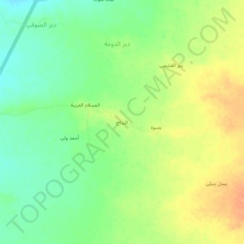
Name: Topografische Karte البداح, Höhe, Relief.
Ort: البداح, Az Zuhrah, Gouvernorat d'Al Hudaydah, Yémen (15.73616 43.16702 15.77616 43.20702)
Durchschnittliche Höhe: 147 m
Minimale Höhe: 128 m
Maximale Höhe: 167 m
Andere topografische Karten
Klicken Sie auf eine Karte, um ihre Topografie, ihre Höhe und ihr Relief anzuzeigen.
Az Zaydiyah
Yémen > Gouvernorat d'Al Hudaydah
Az Zaydiyah, Mudiriyat Az Zaydiyah, Gouvernorat d'Al Hudaydah, Yémen
Durchschnittliche Höhe: 56 m
Al Mahdayn
Yémen > Gouvernorat d'Al Hudaydah
Al Mahdayn, Al Marawiah, Gouvernorat d'Al Hudaydah, Yémen
Durchschnittliche Höhe: 105 m
Guil
Yémen > Gouvernorat d'Al Hudaydah
Guil, Bajil, Gouvernorat d'Al Hudaydah, Yémen
Durchschnittliche Höhe: 28 m
كتامة
Yémen > Gouvernorat d'Al Hudaydah
كتامة, Al Luhayyah, Gouvernorat d'Al Hudaydah, Yémen
Durchschnittliche Höhe: 2 m
السلعة
Yémen > Gouvernorat d'Al Hudaydah > Al Maqfa` > السلعة
السلعة, Al Maqfa`, مديرية برع, Gouvernorat d'Al Hudaydah, Yémen
Durchschnittliche Höhe: 752 m
Djébel Teir
Yémen > Gouvernorat d'Al Hudaydah
Djébel Teir, Kamaran, Gouvernorat d'Al Hudaydah, Yémen
Durchschnittliche Höhe: 51 m
Kahma
Yémen > Gouvernorat d'Al Hudaydah > Al Kidiyah > Kahma
Kahma, Al Kidiyah, Bayt al Faqih, Gouvernorat d'Al Hudaydah, Yémen
Durchschnittliche Höhe: 71 m
Ash Sharqiyah
Yémen > Gouvernorat d'Al Hudaydah > Ash Sharqiyah
Ash Sharqiyah, Gouvernorat d'Al Hudaydah, Yémen
Durchschnittliche Höhe: 72 m