
Topografische Karte Strathcona Science Provincial Park
Interaktive Karte
Klicken Sie auf die Karte, um die Höhe anzuzeigen.
Über diese Karte
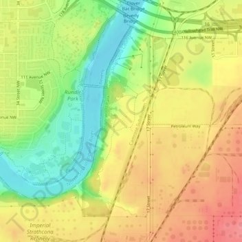
Name: Topografische Karte Strathcona Science Provincial Park, Höhe, Relief.
Durchschnittliche Höhe: 653 m
Minimale Höhe: 608 m
Maximale Höhe: 691 m
The park is situated in the North Saskatchewan River valley, on both banks of the river, at an elevation of 625 m (2,051 ft) and has a surface of 2.9 km2 (1.1 sq mi). It was established on December 12, 1979 and is maintained by Alberta Tourism, Parks and Recreation.
Andere topografische Karten
Klicken Sie auf eine Karte, um ihre Topografie, ihre Höhe und ihr Relief anzuzeigen.
Sherwood Park
Canada > Alberta > Strathcona County > Sherwood Park
Sherwood Park, Strathcona County, Alberta, Canada
Durchschnittliche Höhe: 691 m