
Topografische Karte Hrabušice
Interaktive Karte
Klicken Sie auf die Karte, um die Höhe anzuzeigen.
Über diese Karte
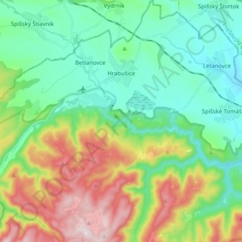
Name: Topografische Karte Hrabušice, Höhe, Relief.
Durchschnittliche Höhe: 671 m
Minimale Höhe: 498 m
Maximale Höhe: 1.049 m
The village lies at an altitude of 548 metres and covers an area of 40.886 km². In 2011 Hrabušice had a population of about 2,378 inhabitants.
Andere topografische Karten
Klicken Sie auf eine Karte, um ihre Topografie, ihre Höhe und ihr Relief anzuzeigen.
Suchá Belá
Slovakia > Region of Košice > District of Spišská Nová Ves > Hrabušice
Suchá Belá, Hrabušice, District of Spišská Nová Ves, Region of Košice, Eastern Slovakia, Slovakia
Durchschnittliche Höhe: 781 m
Spišská Nová Ves
Slovakia > Region of Košice > District of Spišská Nová Ves
Spišská Nová Ves, District of Spišská Nová Ves, Region of Košice, Eastern Slovakia, Slovakia
Durchschnittliche Höhe: 619 m