
Topografische Karte Hart County
Interaktive Karte
Klicken Sie auf die Karte, um die Höhe anzuzeigen.
Über diese Karte
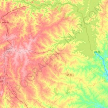
Name: Topografische Karte Hart County, Höhe, Relief.
Ort: Hart County, Georgia, United States of America (34.21016 -83.11585 34.49376 -82.77406)
Durchschnittliche Höhe: 225 m
Minimale Höhe: 144 m
Maximale Höhe: 296 m
Andere topografische Karten
Klicken Sie auf eine Karte, um ihre Topografie, ihre Höhe und ihr Relief anzuzeigen.
Murray County
United States of America > Georgia
Murray County, Georgia, United States of America
Durchschnittliche Höhe: 381 m
Americus
United States of America > Georgia > Americus
Americus, Sumter County, Georgia, 31709, United States of America
Durchschnittliche Höhe: 125 m
Coffee County
United States of America > Georgia
Coffee County, Georgia, United States of America
Durchschnittliche Höhe: 72 m
Poetry
United States of America > Georgia > Poetry
Poetry, Chattooga County, Georgia, United States of America
Durchschnittliche Höhe: 277 m
Ben Hill County
United States of America > Georgia
Ben Hill County, Georgia, 31750, United States of America
Durchschnittliche Höhe: 88 m
Towns County
United States of America > Georgia
Towns County, Georgia, United States of America
Durchschnittliche Höhe: 764 m