
Spenden
Rüsten Sie sich für Ihr nächstes Abenteuer:
Als Amazon-Partner erhält diese Website eine Provision für qualifizierte Käufe, ohne zusätzliche Kosten für Sie.
Topografische Karte Joshua Tree
Klicken Sie auf die Karte, um die Höhe anzuzeigen.
Spenden
Rüsten Sie sich für Ihr nächstes Abenteuer:
Als Amazon-Partner erhält diese Website eine Provision für qualifizierte Käufe, ohne zusätzliche Kosten für Sie.
Über diese Karte
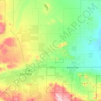
Name: Topografische Karte Joshua Tree, Höhe, Relief.
Durchschnittliche Höhe: 1.010 m
Minimale Höhe: 735 m
Maximale Höhe: 1.501 m
Spenden
Rüsten Sie sich für Ihr nächstes Abenteuer:
Als Amazon-Partner erhält diese Website eine Provision für qualifizierte Käufe, ohne zusätzliche Kosten für Sie.
Andere topografische Karten
Klicken Sie auf eine Karte, um ihre Topografie, ihre Höhe und ihr Relief anzuzeigen.
North Fontana
United States > California > San Bernardino County > Fontana
Durchschnittliche Höhe: 463 m
Yucca Valley
United States > California > San Bernardino County
Yucca Valley lies in the middle of the Morongo Basin at a base elevation of 3,300 feet. Joshua Tree National Park is adjacent to its southern border.
Durchschnittliche Höhe: 1.106 m
Spenden
Rüsten Sie sich für Ihr nächstes Abenteuer:
Als Amazon-Partner erhält diese Website eine Provision für qualifizierte Käufe, ohne zusätzliche Kosten für Sie.
North Shore
United States > California > San Bernardino County > Lake Arrowhead
Durchschnittliche Höhe: 1.585 m
Desert Knolls Manor
United States > California > San Bernardino County > Apple Valley
Durchschnittliche Höhe: 928 m
Crestline
United States > California > San Bernardino County > Crestline
Durchschnittliche Höhe: 1.301 m
Spenden
Rüsten Sie sich für Ihr nächstes Abenteuer:
Als Amazon-Partner erhält diese Website eine Provision für qualifizierte Käufe, ohne zusätzliche Kosten für Sie.
Santa Ana River Trail & Parkway
United States > California > San Bernardino County > San Bernardino
Durchschnittliche Höhe: 310 m
Spenden
Rüsten Sie sich für Ihr nächstes Abenteuer:
Als Amazon-Partner erhält diese Website eine Provision für qualifizierte Käufe, ohne zusätzliche Kosten für Sie.
Sugarloaf
United States > California > San Bernardino County > Victorville
Durchschnittliche Höhe: 844 m
Spenden
Rüsten Sie sich für Ihr nächstes Abenteuer:
Als Amazon-Partner erhält diese Website eine Provision für qualifizierte Käufe, ohne zusätzliche Kosten für Sie.
Big Bear City
United States > California > San Bernardino County
It is estimated that the Serrano natives first settled in Big Bear between 1,500 and 2,000 years ago. The Serranos had both winter and summer settlements throughout the area. While their winter village was located in Lucerne Valley, they relocated to villages in the San Bernardino mountains during summer, as…
Durchschnittliche Höhe: 2.167 m
Eagle Ranch
United States > California > San Bernardino County > Victorville
Durchschnittliche Höhe: 1.006 m
Spenden
Rüsten Sie sich für Ihr nächstes Abenteuer:
Als Amazon-Partner erhält diese Website eine Provision für qualifizierte Käufe, ohne zusätzliche Kosten für Sie.
Fort Irwin
United States > California > San Bernardino County
Fort Irwin National Training Center (Fort Irwin NTC) is a major training area for the United States military in the Mojave Desert in northern San Bernardino County, California. Fort Irwin is at an average elevation of 2,454 feet (748 m). It is located 37 miles (60 km) northeast of Barstow, in the Calico…
Durchschnittliche Höhe: 774 m
Arrowhead Highlands
United States > California > San Bernardino County > Crestline
Durchschnittliche Höhe: 1.405 m
Sugarloaf
United States > California > San Bernardino County > Big Bear City
Durchschnittliche Höhe: 2.154 m
Spenden
Rüsten Sie sich für Ihr nächstes Abenteuer:
Als Amazon-Partner erhält diese Website eine Provision für qualifizierte Käufe, ohne zusätzliche Kosten für Sie.
Big Bear City
United States > California > San Bernardino County > Big Bear City
It is estimated that the Serrano natives first settled in Big Bear between 1,500 and 2,000 years ago. The Serranos had both winter and summer settlements throughout the area. While their winter village was located in Lucerne Valley, they relocated to villages in the San Bernardino mountains during summer, as…
Durchschnittliche Höhe: 2.155 m
Spenden
Rüsten Sie sich für Ihr nächstes Abenteuer:
Als Amazon-Partner erhält diese Website eine Provision für qualifizierte Käufe, ohne zusätzliche Kosten für Sie.
High Country
United States > California > San Bernardino County > Hesperia
Durchschnittliche Höhe: 1.104 m
Grand Terrace
United States > California > San Bernardino County > Grand Terrace > Grand Terrace
This 3.6-square-mile (9.3 km2) community has an average elevation of 1,065 feet (325 m). Its motto, inscribed on the city flag, is "The Blue Mountain City" (its official slogan is "A city set upon a mountain cannot be hidden"), and refers to the Blue Lupine flower that used to grow on Blue Mountain in the…
Durchschnittliche Höhe: 345 m
Spenden
Rüsten Sie sich für Ihr nächstes Abenteuer:
Als Amazon-Partner erhält diese Website eine Provision für qualifizierte Käufe, ohne zusätzliche Kosten für Sie.
Spenden
Rüsten Sie sich für Ihr nächstes Abenteuer:
Als Amazon-Partner erhält diese Website eine Provision für qualifizierte Käufe, ohne zusätzliche Kosten für Sie.
Serrano Village
United States > California > San Bernardino County > San Bernardino
Durchschnittliche Höhe: 489 m
Spenden
Rüsten Sie sich für Ihr nächstes Abenteuer:
Als Amazon-Partner erhält diese Website eine Provision für qualifizierte Käufe, ohne zusätzliche Kosten für Sie.
Shadow Hills
United States > California > San Bernardino County > Adelanto
Durchschnittliche Höhe: 849 m
Grapeland
United States > California > San Bernardino County > Rancho Cucamonga
Durchschnittliche Höhe: 423 m
Fredalba
United States > California > San Bernardino County > Running Springs
Durchschnittliche Höhe: 1.547 m
Spenden
Rüsten Sie sich für Ihr nächstes Abenteuer:
Als Amazon-Partner erhält diese Website eine Provision für qualifizierte Käufe, ohne zusätzliche Kosten für Sie.
Spenden
Rüsten Sie sich für Ihr nächstes Abenteuer:
Als Amazon-Partner erhält diese Website eine Provision für qualifizierte Käufe, ohne zusätzliche Kosten für Sie.
Lake Gregory
United States > California > San Bernardino County > Crestline
Durchschnittliche Höhe: 1.452 m
Badger Hill
United States > California > San Bernardino County > San Bernardino
Durchschnittliche Höhe: 525 m
Golden Mesa
United States > California > San Bernardino County > Victorville
Durchschnittliche Höhe: 887 m
Spenden
Rüsten Sie sich für Ihr nächstes Abenteuer:
Als Amazon-Partner erhält diese Website eine Provision für qualifizierte Käufe, ohne zusätzliche Kosten für Sie.
Parker Dam
United States > California > San Bernardino County > Parker Dam
Durchschnittliche Höhe: 181 m
Spenden
Rüsten Sie sich für Ihr nächstes Abenteuer:
Als Amazon-Partner erhält diese Website eine Provision für qualifizierte Käufe, ohne zusätzliche Kosten für Sie.
Etiwanda
United States > California > San Bernardino County > Rancho Cucamonga
Durchschnittliche Höhe: 415 m
Spenden
Rüsten Sie sich für Ihr nächstes Abenteuer:
Als Amazon-Partner erhält diese Website eine Provision für qualifizierte Käufe, ohne zusätzliche Kosten für Sie.
Rochester
United States > California > San Bernardino County > Rancho Cucamonga > Rochester
Durchschnittliche Höhe: 343 m
North Ontario
United States > California > San Bernardino County > Upland > North Ontario
Durchschnittliche Höhe: 373 m
Spenden
Rüsten Sie sich für Ihr nächstes Abenteuer:
Als Amazon-Partner erhält diese Website eine Provision für qualifizierte Käufe, ohne zusätzliche Kosten für Sie.
Baldy Mesa
United States > California > San Bernardino County > Baldy Mesa
Durchschnittliche Höhe: 1.065 m
Rialto City Park
United States > California > San Bernardino County > Rialto
Durchschnittliche Höhe: 340 m
Spenden
Rüsten Sie sich für Ihr nächstes Abenteuer:
Als Amazon-Partner erhält diese Website eine Provision für qualifizierte Käufe, ohne zusätzliche Kosten für Sie.