
Topografische Karte Cape York
Interaktive Karte
Klicken Sie auf die Karte, um die Höhe anzuzeigen.
Über diese Karte
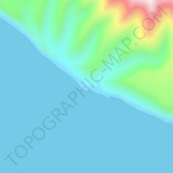
Name: Topografische Karte Cape York, Höhe, Relief.
Ort: Cape York, Nome, Alaska, United States of America (65.41445 -167.46464 65.41455 -167.46454)
Durchschnittliche Höhe: 75 m
Minimale Höhe: 0 m
Maximale Höhe: 556 m
Andere topografische Karten
Klicken Sie auf eine Karte, um ihre Topografie, ihre Höhe und ihr Relief anzuzeigen.
Noatak
United States of America > Alaska > Noatak
Noatak, Northwest Arctic, Alaska, United States of America
Durchschnittliche Höhe: 23 m
Johns
United States of America > Alaska
Johns, Unorganized Borough, Alaska, United States of America
Durchschnittliche Höhe: 823 m
Mount Pendleton
United States of America > Alaska
Mount Pendleton, Denali, Alaska, United States of America
Durchschnittliche Höhe: 1.978 m
Aleutians East
United States of America > Alaska
Aleutians East, Alaska, United States of America
Durchschnittliche Höhe: 23 m
North Slope
United States of America > Alaska
North Slope, Alaska, United States of America
Durchschnittliche Höhe: 214 m
Northwest Arctic
United States of America > Alaska
Northwest Arctic, Alaska, United States of America
Durchschnittliche Höhe: 296 m
Denali National Park and Preserve
United States of America > Alaska
Denali National Park and Preserve, Alaska, United States of America
Durchschnittliche Höhe: 777 m