
Topografische Karte Big Brook
Interaktive Karte
Klicken Sie auf die Karte, um die Höhe anzuzeigen.
Über diese Karte
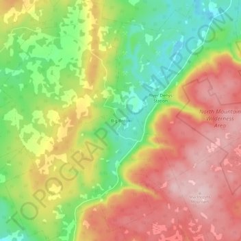
Name: Topografische Karte Big Brook, Höhe, Relief.
Durchschnittliche Höhe: 127 m
Minimale Höhe: 6 m
Maximale Höhe: 251 m
Andere topografische Karten
Klicken Sie auf eine Karte, um ihre Topografie, ihre Höhe und ihr Relief anzuzeigen.
West Bay
Canada > Nova Scotia > Municipality of the County of Inverness
West Bay, Municipality of the County of Inverness, Inverness County, Nova Scotia, Canada
Durchschnittliche Höhe: 109 m
Mull River
Canada > Nova Scotia > Municipality of the County of Inverness > Mabou
Mull River, Mabou, Municipality of the County of Inverness, Inverness County, Nova Scotia, Canada
Durchschnittliche Höhe: 83 m
Dunmore
Canada > Nova Scotia > Municipality of the County of Inverness
Dunmore, Municipality of the County of Inverness, Inverness County, Nova Scotia, Canada
Durchschnittliche Höhe: 28 m
Point Cross
Canada > Nova Scotia > Municipality of the County of Inverness > Point Cross
Point Cross, Municipality of the County of Inverness, Inverness County, Nova Scotia, Canada
Durchschnittliche Höhe: 97 m
Mabou
Canada > Nova Scotia > Municipality of the County of Inverness > Mabou
Mabou, Municipality of the County of Inverness, Inverness County, Nova Scotia, Canada
Durchschnittliche Höhe: 81 m
Gillis Cove
Canada > Nova Scotia > Municipality of the County of Inverness
Gillis Cove, Municipality of the County of Inverness, Inverness County, Nova Scotia, Canada
Durchschnittliche Höhe: 13 m
Kewstoke
Canada > Nova Scotia > Municipality of the County of Inverness
Kewstoke, Municipality of the County of Inverness, Inverness County, Nova Scotia, Canada
Durchschnittliche Höhe: 161 m
Whycocomagh
Canada > Nova Scotia > Municipality of the County of Inverness
Whycocomagh, Municipality of the County of Inverness, Inverness County, Nova Scotia, B0E 3M0, Canada
Durchschnittliche Höhe: 135 m
Pleasant Bay
Canada > Nova Scotia > Municipality of the County of Inverness
Pleasant Bay, Municipality of the County of Inverness, Inverness County, Nova Scotia, B0E 2P0, Canada
Durchschnittliche Höhe: 80 m