
Topografische Karte Courmayeur
Interaktive Karte
Klicken Sie auf die Karte, um die Höhe anzuzeigen.
Über diese Karte
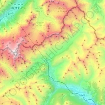
Name: Topografische Karte Courmayeur, Höhe, Relief.
Ort: Courmayeur, Aosta Valley, 11013, Italy (45.74005 6.80153 45.92302 7.10155)
Durchschnittliche Höhe: 2.366 m
Minimale Höhe: 819 m
Maximale Höhe: 4.800 m
At an elevation of 1,224 m (4,016 ft) above sea level, it is located at the foot of the southern side of Mont Blanc, at 4,810 m (15,781 ft) the highest point in the Alps and western Europe (see Seven Summits), and is crossed by the Dora Baltea (fr. Doire baltée) river.
Andere topografische Karten
Klicken Sie auf eine Karte, um ihre Topografie, ihre Höhe und ihr Relief anzuzeigen.
Pointe Helbronner / Punta Helbronner
Italy > Aosta Valley > Courmayeur
Pointe Helbronner / Punta Helbronner, Courmayeur, Aosta Valley, Italy
Durchschnittliche Höhe: 3.072 m
Saint-Rhémy-en-Bosses
Saint-Rhémy-en-Bosses, Aosta Valley, Italy
Durchschnittliche Höhe: 2.181 m
Maen
Maen, Valtournenche, Aosta Valley, 11028, Italy
Durchschnittliche Höhe: 1.877 m
Paquier
Italy > Aosta Valley > Saint-Marcel
Paquier, Saint-Marcel, Aosta Valley, Italy
Durchschnittliche Höhe: 718 m
Evian
Italy > Aosta Valley > Saint-Nicolas
Evian, Saint-Nicolas, Aosta Valley, 11018, Italy
Durchschnittliche Höhe: 1.022 m
Ghiacciaio di Cherillon
Italy > Aosta Valley > Valtournenche
Ghiacciaio di Cherillon, Valtournenche, Aosta Valley, Italy
Durchschnittliche Höhe: 3.155 m
Chevril
Italy > Aosta Valley > Aymavilles
Chevril, Aymavilles, Aosta Valley, 11010, Italy
Durchschnittliche Höhe: 1.428 m
Lillaz
Lillaz, Antey-Saint-André, Aosta Valley, 11020, Italy
Durchschnittliche Höhe: 1.545 m
Le Pont
Italy > Aosta Valley > Valsavarenche
Le Pont, Valsavarenche, Aosta Valley, Italy
Durchschnittliche Höhe: 2.410 m
Liex
Italy > Aosta Valley > Epaillon
Liex, Epaillon, Antey-Saint-André, Aosta Valley, 11020, Italy
Durchschnittliche Höhe: 1.327 m
Parco Naturale del Mont Avic
Italy > Aosta Valley > Champdepraz
Parco Naturale del Mont Avic, Champdepraz, Aosta Valley, Italy
Durchschnittliche Höhe: 2.081 m
Castello Gamba
Italy > Aosta Valley > Châtillon > Sétoret
Castello Gamba, Strada Comunale Cret De Breil, Sétoret, Châtillon, Aosta Valley, 11024, Italy
Durchschnittliche Höhe: 687 m
Gros-Breil
Italy > Aosta Valley > Châtillon
Gros-Breil, Châtillon, Aosta Valley, 11024, Italy
Durchschnittliche Höhe: 845 m
Creton
Creton, Étroubles, Aosta Valley, 11014, Italy
Durchschnittliche Höhe: 1.681 m
Pussey
Italy > Aosta Valley > Courmayeur
Pussey, Courmayeur, Aosta Valley, 11013, Italy
Durchschnittliche Höhe: 1.561 m
Pré-Saint-Didier
Pré-Saint-Didier, Aosta Valley, Italy
Durchschnittliche Höhe: 1.795 m
Lago di Place Moulin
Lago di Place Moulin, Bionaz, Aosta Valley, Italy
Durchschnittliche Höhe: 2.297 m
Mont du Clapey
Italy > Aosta Valley > Oyace
Mont du Clapey, Oyace, Aosta Valley, Italy
Durchschnittliche Höhe: 2.748 m
Mont d'Ars
Italy > Aosta Valley > Gignod
Mont d'Ars, Gignod, Aosta Valley, 11014, Italy
Durchschnittliche Höhe: 2.456 m
Alpe Chomioi
Italy > Aosta Valley > Torgnon
Alpe Chomioi, Torgnon, Aosta Valley, Italy
Durchschnittliche Höhe: 2.307 m
Pic Eccles
Italy > Aosta Valley > Courmayeur
Pic Eccles, Courmayeur, Aosta Valley, Italy
Durchschnittliche Höhe: 3.722 m
Le Breuil - Cervinia
Le Breuil - Cervinia, Valtournenche, Aosta Valley, 11021, Italy
Durchschnittliche Höhe: 2.376 m
Testa d'Arpy
Italy > Aosta Valley > Morgex
Testa d'Arpy, Morgex, Aosta Valley, 11017, Italy
Durchschnittliche Höhe: 1.651 m
Ostafa Desot
Italy > Aosta Valley > Ayas
Ostafa Desot, Ayas, Aosta Valley, 11020, Italy
Durchschnittliche Höhe: 2.275 m
Cotes
Italy > Aosta Valley > Gressan
Cotes, Gressan, Aosta Valley, 11100, Italy
Durchschnittliche Höhe: 981 m
Monte Rosa Massif
Italy > Aosta Valley > Gressoney-La-Trinité
Monte Rosa Massif, Gressoney-La-Trinité, Aosta Valley, Italy
Durchschnittliche Höhe: 3.478 m
Fiernaz Dessous
Fiernaz Dessous, Antey-Saint-André, Aosta Valley, 11020, Italy
Durchschnittliche Höhe: 1.599 m
Edelboden inferiore
Italy > Aosta Valley > Gressoney-La-Trinité
Edelboden inferiore, Gressoney-La-Trinité, Aosta Valley, Italy
Durchschnittliche Höhe: 2.167 m
Entrèves
Italy > Aosta Valley > Courmayeur
Entrèves, Courmayeur, Aosta Valley, 11013, Italy
Durchschnittliche Höhe: 1.702 m
Paquier
Italy > Aosta Valley > Gressan > Paquier
Paquier, Gressan, Aosta Valley, 11100, Italy
Durchschnittliche Höhe: 801 m
Saint-Vincent
Saint-Vincent, Aosta Valley, 11027, Italy
Durchschnittliche Höhe: 1.179 m
Gran Paradiso
Italy > Aosta Valley > Valsavarenche
Gran Paradiso, Valsavarenche, Aosta Valley, Italy
Durchschnittliche Höhe: 3.459 m
Planet
Italy > Aosta Valley > Donnas > Planet
Planet, Donnas, Aosta Valley, 11020, Italy
Durchschnittliche Höhe: 794 m
Larzey
Italy > Aosta Valley > Courmayeur > Larzey
Larzey, Courmayeur, Aosta Valley, 11013, Italy
Durchschnittliche Höhe: 1.596 m
Chopine
Italy > Aosta Valley > Torille > Chopine
Chopine, Torille, Verrès, Aosta Valley, 11029, Italy
Durchschnittliche Höhe: 610 m
Gressoney-Saint-Jean
Gressoney-Saint-Jean, Aosta Valley, 11025, Italy
Durchschnittliche Höhe: 2.179 m
Clavon
Italy > Aosta Valley > Verrayes > Clavon
Clavon, Verrayes, Aosta Valley, Italy
Durchschnittliche Höhe: 1.574 m
La Thuile
Italy > Aosta Valley > La Thuile
La Thuile, Aosta Valley, Italy
Durchschnittliche Höhe: 2.257 m
Weissmatten
Italy > Aosta Valley > Gressoney-Saint-Jean
Weissmatten, Gressoney-Saint-Jean, Aosta Valley, 11025, Italy
Durchschnittliche Höhe: 1.932 m
Lago Gabiet
Italy > Aosta Valley > Gressoney-La-Trinité
Lago Gabiet, 5, Batt, Gressoney-La-Trinité, Aosta Valley, Italy
Durchschnittliche Höhe: 2.433 m