
Topografische Karte Trikala Municipality
Interaktive Karte
Klicken Sie auf die Karte, um die Höhe anzuzeigen.
Über diese Karte
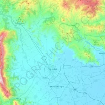
Name: Topografische Karte Trikala Municipality, Höhe, Relief.
Durchschnittliche Höhe: 350 m
Minimale Höhe: 88 m
Maximale Höhe: 1.801 m
Andere topografische Karten
Klicken Sie auf eine Karte, um ihre Topografie, ihre Höhe und ihr Relief anzuzeigen.
Meteora
Greece > Thessaly and Central Greece > Trikala Regional Unit > Kastraki
Meteora, Kastraki, Meteora Municipality, Trikala Regional Unit, Thessaly, Thessaly and Central Greece, 422 00, Greece
Durchschnittliche Höhe: 428 m
Pinios (Thessalia)
Greece > Thessaly and Central Greece > Trikala Regional Unit > Trikala Municipality
Pinios (Thessalia), Trikala Municipality, Trikala Regional Unit, Thessaly, Thessaly and Central Greece, Greece
Durchschnittliche Höhe: 119 m
Καλαμπάκα
Greece > Thessaly and Central Greece > Trikala Regional Unit
Καλαμπάκα, Meteora Municipality, Trikala Regional Unit, Thessaly, Thessaly and Central Greece, 422 00, Greece
Durchschnittliche Höhe: 339 m
Lipiota
Greece > Thessaly and Central Greece > Trikala Regional Unit > Vrontero
Lipiota, Vrontero, Pyli Municipality, Trikala Regional Unit, Thessaly, Thessaly and Central Greece, 420 32, Greece
Durchschnittliche Höhe: 1.165 m
Devil's tower
Greece > Thessaly and Central Greece > Trikala Regional Unit > Καλαμπάκα
Devil's tower, Καλαμπάκα, Meteora Municipality, Trikala Regional Unit, Thessaly, Thessaly and Central Greece, 422 00, Greece
Durchschnittliche Höhe: 414 m
Fourka
Greece > Thessaly and Central Greece > Trikala Regional Unit
Fourka, Pyli Municipality, Trikala Regional Unit, Thessaly, Thessaly and Central Greece, Greece
Durchschnittliche Höhe: 1.688 m