
Spenden
Rüsten Sie sich für Ihr nächstes Abenteuer:
Als Amazon-Partner erhält diese Website eine Provision für qualifizierte Käufe, ohne zusätzliche Kosten für Sie.
Topografische Karte Frodsham
Klicken Sie auf die Karte, um die Höhe anzuzeigen.
Spenden
Rüsten Sie sich für Ihr nächstes Abenteuer:
Als Amazon-Partner erhält diese Website eine Provision für qualifizierte Käufe, ohne zusätzliche Kosten für Sie.
Frodsham
Several faults run roughly northwest–southeast through the area, notably the Overton Fault, which roughly parallels the B5439 and B5152 roads, and the Frodsham Fault, which runs north from the vicinity of Crowmere to the mouth of the River Weaver. Both of these faults and others in the area downthrow to the east. Movement on them is thought to have taken place in the Tertiary period. The uplift resulted in trapping the water table at an elevation of around 200 feet (61 m) at which level springs developed.
Spenden
Rüsten Sie sich für Ihr nächstes Abenteuer:
Als Amazon-Partner erhält diese Website eine Provision für qualifizierte Käufe, ohne zusätzliche Kosten für Sie.
Über diese Karte
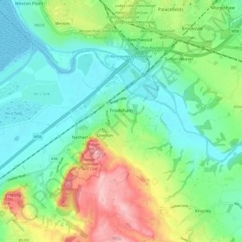
Name: Topografische Karte Frodsham, Höhe, Relief.
Ort: Frodsham, Cheshire West and Chester, England, United Kingdom (53.26112 -2.79169 53.32580 -2.68196)
Durchschnittliche Höhe: 49 m
Minimale Höhe: 0 m
Maximale Höhe: 156 m
Spenden
Rüsten Sie sich für Ihr nächstes Abenteuer:
Als Amazon-Partner erhält diese Website eine Provision für qualifizierte Käufe, ohne zusätzliche Kosten für Sie.
Andere topografische Karten
Klicken Sie auf eine Karte, um ihre Topografie, ihre Höhe und ihr Relief anzuzeigen.
Broken Cross
United Kingdom > England > Cheshire West and Chester > Lostock Green
Durchschnittliche Höhe: 28 m
Delamere Forest
United Kingdom > England > Cheshire West and Chester
This part of Delamere Forest is undulating in character, with elevations predominantly in the range 60–90 metres. It is composed of numerous hummocks and peatland basins, some of which are glacial in origin while others have been created by sand extraction. The basins form lakes and mosses (bogs) within the…
Durchschnittliche Höhe: 90 m
Spenden
Rüsten Sie sich für Ihr nächstes Abenteuer:
Als Amazon-Partner erhält diese Website eine Provision für qualifizierte Käufe, ohne zusätzliche Kosten für Sie.
Peckforton Castle
United Kingdom > England > Cheshire West and Chester > Beeston
Peckforton Castle stands in a wooded area near the northern extremity of Peckforton Hills at an elevation of 469.2 feet (143 m). The land falls steeply downwards to the north and the west of the castle, and the Sandstone Trail, a long-distance footpath, runs along the base of these slopes. The ruins of Beeston…
Durchschnittliche Höhe: 83 m
Oldcastle Heath
United Kingdom > England > Cheshire West and Chester > Malpas
Durchschnittliche Höhe: 77 m
Spenden
Rüsten Sie sich für Ihr nächstes Abenteuer:
Als Amazon-Partner erhält diese Website eine Provision für qualifizierte Käufe, ohne zusätzliche Kosten für Sie.
Beeston Castle
United Kingdom > England > Cheshire West and Chester > Beeston
Durchschnittliche Höhe: 60 m
Spenden
Rüsten Sie sich für Ihr nächstes Abenteuer:
Als Amazon-Partner erhält diese Website eine Provision für qualifizierte Käufe, ohne zusätzliche Kosten für Sie.
Eddisbury Hill
United Kingdom > England > Cheshire West and Chester > Delamere
Durchschnittliche Höhe: 103 m
Spenden
Rüsten Sie sich für Ihr nächstes Abenteuer:
Als Amazon-Partner erhält diese Website eine Provision für qualifizierte Käufe, ohne zusätzliche Kosten für Sie.
Dutton Small Lock (Disused)
United Kingdom > England > Cheshire West and Chester > Acton Bridge > Dutton
Durchschnittliche Höhe: 28 m
Dutton Locks
United Kingdom > England > Cheshire West and Chester > Acton Bridge > Dutton
Durchschnittliche Höhe: 28 m
Spenden
Rüsten Sie sich für Ihr nächstes Abenteuer:
Als Amazon-Partner erhält diese Website eine Provision für qualifizierte Käufe, ohne zusätzliche Kosten für Sie.
Countess of Chester Country Park
United Kingdom > England > Cheshire West and Chester > Chester
Durchschnittliche Höhe: 21 m
Bolesworth Castle
United Kingdom > England > Cheshire West and Chester > Harthill > Broxton
Durchschnittliche Höhe: 80 m
Bolesworth Fish Pond
United Kingdom > England > Cheshire West and Chester > Harthill > Broxton
Durchschnittliche Höhe: 75 m
Spenden
Rüsten Sie sich für Ihr nächstes Abenteuer:
Als Amazon-Partner erhält diese Website eine Provision für qualifizierte Käufe, ohne zusätzliche Kosten für Sie.
Wirral Country Park
United Kingdom > England > Cheshire West and Chester > Neston > Windle Hill
Durchschnittliche Höhe: 49 m
Spenden
Rüsten Sie sich für Ihr nächstes Abenteuer:
Als Amazon-Partner erhält diese Website eine Provision für qualifizierte Käufe, ohne zusätzliche Kosten für Sie.
Clutton Hill
United Kingdom > England > Cheshire West and Chester > Clutton
Durchschnittliche Höhe: 46 m
Spenden
Rüsten Sie sich für Ihr nächstes Abenteuer:
Als Amazon-Partner erhält diese Website eine Provision für qualifizierte Käufe, ohne zusätzliche Kosten für Sie.
Black Diamond Park
United Kingdom > England > Cheshire West and Chester > Chester
Durchschnittliche Höhe: 21 m
Spenden
Rüsten Sie sich für Ihr nächstes Abenteuer:
Als Amazon-Partner erhält diese Website eine Provision für qualifizierte Käufe, ohne zusätzliche Kosten für Sie.
Spenden
Rüsten Sie sich für Ihr nächstes Abenteuer:
Als Amazon-Partner erhält diese Website eine Provision für qualifizierte Käufe, ohne zusätzliche Kosten für Sie.
Bostock Green
United Kingdom > England > Cheshire West and Chester > Bostock Green
Durchschnittliche Höhe: 36 m
Brown Heath
United Kingdom > England > Cheshire West and Chester > Brown Heath
Durchschnittliche Höhe: 30 m
Spenden
Rüsten Sie sich für Ihr nächstes Abenteuer:
Als Amazon-Partner erhält diese Website eine Provision für qualifizierte Käufe, ohne zusätzliche Kosten für Sie.
Eddisbury Hill Fort
United Kingdom > England > Cheshire West and Chester > Delamere
Durchschnittliche Höhe: 103 m
Roman Fort
United Kingdom > England > Cheshire West and Chester > Chester
Durchschnittliche Höhe: 21 m
Chester Castle
United Kingdom > England > Cheshire West and Chester > Chester
Durchschnittliche Höhe: 18 m
Meadowbank
United Kingdom > England > Cheshire West and Chester > Winsford > Meadowbank
Durchschnittliche Höhe: 40 m
Spenden
Rüsten Sie sich für Ihr nächstes Abenteuer:
Als Amazon-Partner erhält diese Website eine Provision für qualifizierte Käufe, ohne zusätzliche Kosten für Sie.
River Mersey
United Kingdom > England > Cheshire West and Chester > Bromborough
Durchschnittliche Höhe: 8 m
Delamere Forest
United Kingdom > England > Cheshire West and Chester
This part of Delamere Forest is undulating in character, with elevations predominantly in the range 60–90 metres. It is composed of numerous hummocks and peatland basins, some of which are glacial in origin while others have been created by sand extraction. The basins form lakes and mosses (bogs) within the…
Durchschnittliche Höhe: 90 m
Spenden
Rüsten Sie sich für Ihr nächstes Abenteuer:
Als Amazon-Partner erhält diese Website eine Provision für qualifizierte Käufe, ohne zusätzliche Kosten für Sie.