
Topografische Karte Macquarie Island
Interaktive Karte
Klicken Sie auf die Karte, um die Höhe anzuzeigen.
Über diese Karte
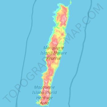
Name: Topografische Karte Macquarie Island, Höhe, Relief.
Ort: Macquarie Island, Huon Valley, Tasmania, Australia (-54.77699 158.77815 -54.48663 158.94701)
Durchschnittliche Höhe: 20 m
Minimale Höhe: 0 m
Maximale Höhe: 395 m
Macquarie Island is about 34 km (21 mi) long and 5 km (3 mi) wide, with an area of 128 km2 (49 sq mi). The island consists of plateaus at north and south ends, each of 150–200 m (490–660 ft) elevation, joined by a low, narrow isthmus. The high points include Mount Elder on the north-east coastal ridge at 385 m (1,263 ft), and Mounts Hamilton and Fletcher in the south at 410 m (1,345 ft). The island is almost equidistant between the island of Tasmania and the Antarctic continent's Anderson Peninsula (about 1,500 km (930 mi) to either point). In addition, Macquarie Island is about 630 km (390 mi) south-west of Auckland Island, and 1,300 km (810 mi) north of the Balleny Islands.
Andere topografische Karten
Klicken Sie auf eine Karte, um ihre Topografie, ihre Höhe und ihr Relief anzuzeigen.
Jackeys Marsh
Jackeys Marsh, Meander Valley, Tasmania, 7304, Australia
Durchschnittliche Höhe: 760 m
Goulds Country
Goulds Country, Break O'Day, Tasmania, 7216, Australia
Durchschnittliche Höhe: 308 m
Lake Belton
Lake Belton, Derwent Valley, Tasmania, Australia
Durchschnittliche Höhe: 1.056 m
Vale of Belvoir Conservation Area
Vale of Belvoir Conservation Area, Kentish, Tasmania, Australia
Durchschnittliche Höhe: 866 m
Erith Island
Erith Island, Flinders Council, Tasmania, Australia
Durchschnittliche Höhe: 23 m
Chicken Island
Chicken Island, Huon Valley, Tasmania, Australia
Durchschnittliche Höhe: 4 m
West Hobart
West Hobart, Hobart, City of Hobart, Tasmania, 7000, Australia
Durchschnittliche Höhe: 105 m
Mount Nelson
Mount Nelson, Hobart, City of Hobart, Tasmania, 7007, Australia
Durchschnittliche Höhe: 198 m
Scottsdale
Scottsdale, Dorset, Tasmania, 7260, Australia
Durchschnittliche Höhe: 179 m
Lake Pedder
Australia > Tasmania > Strathgordon
Lake Pedder, Strathgordon, Derwent Valley, Tasmania, Australia
Durchschnittliche Höhe: 366 m
Mersey Forest
Mersey Forest, Meander Valley, Tasmania, Australia
Durchschnittliche Höhe: 866 m
Waratah-Wynyard
Waratah-Wynyard, Tasmania, Australia
Durchschnittliche Höhe: 347 m
Launceston
Launceston, City of Launceston, Tasmania, Australia
Durchschnittliche Höhe: 194 m
Port Arthur
Port Arthur, Tasman, Tasmania, 7182, Australia
Durchschnittliche Höhe: 153 m
Highland Waters
Australia > Tasmania > London Lakes
Highland Waters, London Lakes, Central Highlands, Tasmania, Australia
Durchschnittliche Höhe: 759 m
Bullock Hill
Bullock Hill, Grove, Huon Valley, Tasmania, Australia
Durchschnittliche Höhe: 147 m
Flinders Island
Flinders Island, Tasmania, 7255, Australia
Durchschnittliche Höhe: 20 m
Grey Mares Tail
Australia > Tasmania > St Marys
Grey Mares Tail, St Marys, Break O'Day, Tasmania, Australia
Durchschnittliche Höhe: 349 m
Anderson Island
Anderson Island, Flinders Council, Tasmania, Australia
Durchschnittliche Höhe: 4 m
Bruny Island
Australia > Tasmania > Alonnah
Bruny Island, Alonnah, Kingborough, Tasmania, Australia
Durchschnittliche Höhe: 59 m