
Topografische Karte Indaiatuba
Interaktive Karte
Klicken Sie auf die Karte, um die Höhe anzuzeigen.
Über diese Karte
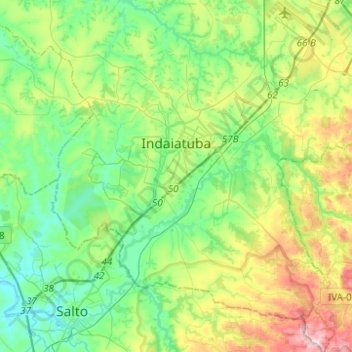
Name: Topografische Karte Indaiatuba, Höhe, Relief.
Durchschnittliche Höhe: 619 m
Minimale Höhe: 497 m
Maximale Höhe: 916 m
Indaiatuba is a municipality in the state of São Paulo in Brazil. It is part of the Metropolitan Region of Campinas. The population is 256,223 (2020 est.) in an area of 311.5 km2 (120.3 sq mi). The elevation is 624 m (2,047 ft) . The city's name derives from the Tupi language. It is an important city in one of Brazil's main industrial regions.