
Topografische Karte Marble Canyon
Interaktive Karte
Klicken Sie auf die Karte, um die Höhe anzuzeigen.
Über diese Karte
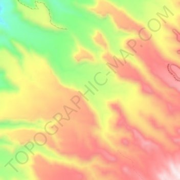
Name: Topografische Karte Marble Canyon, Höhe, Relief.
Ort: Marble Canyon, Grand County, Utah, VS (38.96479 -109.13678 39.00304 -109.07645)
Durchschnittliche Höhe: 1.696 m
Minimale Höhe: 1.323 m
Maximale Höhe: 1.967 m
Andere topografische Karten
Klicken Sie auf eine Karte, um ihre Topografie, ihre Höhe und ihr Relief anzuzeigen.
Bryce Canyon National Park
Bryce Canyon National Park, Under the Rim Trail, Garfield County, Utah, VS
Durchschnittliche Höhe: 2.259 m
Capitol Reef National Park
Capitol Reef National Park, Notom To Oak Creek Road, Garfield County, Utah, VS
Durchschnittliche Höhe: 1.963 m
St. George
VS > Utah > St. George
St. George, Washington County, Utah, VS
Durchschnittliche Höhe: 929 m
Kanarraville
VS > Utah > Kanarraville
Kanarraville, Iron County, Utah, VS
Durchschnittliche Höhe: 1.718 m
Zion National Park
Zion National Park, West Rim Trail, Washington County, Utah, VS
Durchschnittliche Höhe: 1.877 m
Canyonlands National Park
Canyonlands National Park, Wayne County, Utah, VS
Durchschnittliche Höhe: 1.640 m