
Topografische Karte Casey Key
Interaktive Karte
Klicken Sie auf die Karte, um die Höhe anzuzeigen.
Über diese Karte
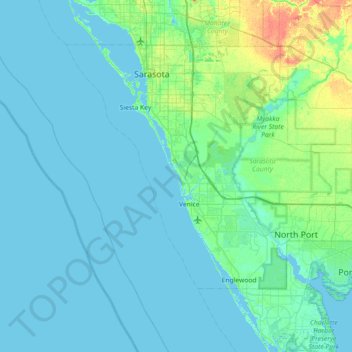
Name: Topografische Karte Casey Key, Höhe, Relief.
Ort: Casey Key, Sarasota County, Florida, 34274, USA (26.83005 -82.80065 27.47005 -82.16065)
Durchschnittliche Höhe: 5 m
Minimale Höhe: -2 m
Maximale Höhe: 35 m
Andere topografische Karten
Klicken Sie auf eine Karte, um ihre Topografie, ihre Höhe und ihr Relief anzuzeigen.
The Villages
USA > Florida > The Villages
The Villages, Lake County, Florida, USA
Durchschnittliche Höhe: 27 m
Yeet Pond
USA > Florida > Palm Coast
Yeet Pond, South Coopers Hawk Way, Palm Coast, Flagler County, Florida, USA
Durchschnittliche Höhe: 7 m
Miami Beach
USA > Florida > Miami Beach
Miami Beach, Miami-Dade County, Florida, USA
Durchschnittliche Höhe: 3 m
Dry Tortugas National Park
Dry Tortugas National Park, Monroe County, Florida, USA
Durchschnittliche Höhe: 0 m
St. Augustine
USA > Florida > St. Augustine
St. Augustine, St. Johns County, Florida, 32084, USA
Durchschnittliche Höhe: 5 m
Deerfield Beach
USA > Florida > Deerfield Beach
Deerfield Beach, Broward County, Florida, USA
Durchschnittliche Höhe: 5 m
Altamonte Springs
USA > Florida > Altamonte Springs
Altamonte Springs, Seminole County, Florida, USA
Durchschnittliche Höhe: 26 m
Dawson Island
USA > Florida > Jacksonville
Dawson Island, Jacksonville, Duval County, Florida, USA
Durchschnittliche Höhe: 2 m