
Topografische Karte Hobart
Interaktive Karte
Klicken Sie auf die Karte, um die Höhe anzuzeigen.
Über diese Karte
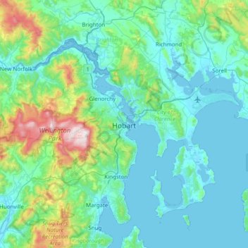
Name: Topografische Karte Hobart, Höhe, Relief.
Ort: Hobart, City of Hobart, Tasmania, Australia (-43.10362 147.09169 -42.65538 147.64559)
Durchschnittliche Höhe: 179 m
Minimale Höhe: -2 m
Maximale Höhe: 1.260 m
Although Hobart itself rarely receives snow during the winter due to the foehn effect created by the Central Highlands (the city's geographic position causes a rainshadow), the adjacent Kunanyi/Mount Wellington is frequently seen with a snowcap throughout the year including in summer. During the 20th century, the city itself has received snowfalls at sea level on average only once every 5 years; however, outer suburbs lying higher on the slopes of Mount Wellington receive snow more often, owing to the more exposed position coupled with them resting at higher altitude. These snow-bearing winds often carry on through Tasmania and Victoria to the Snowy Mountains in Victoria and southern New South Wales.
Andere topografische Karten
Klicken Sie auf eine Karte, um ihre Topografie, ihre Höhe und ihr Relief anzuzeigen.
Elizabeth Town
Elizabeth Town, Meander Valley, Tasmania, 7304, Australia
Durchschnittliche Höhe: 214 m
Lake St Clair
Lake St Clair, Central Highlands, Tasmania, Australia
Durchschnittliche Höhe: 909 m
Lake Louise
Lake Louise, Grindelwald, West Tamar, Tasmania, Australia
Durchschnittliche Höhe: 124 m
Garden Island
Garden Island, Huon Valley, Tasmania, Australia
Durchschnittliche Höhe: 9 m
Mole Creek
Mole Creek, Meander Valley, Tasmania, 7304, Australia
Durchschnittliche Höhe: 440 m
Launceston
Launceston, City of Launceston, Tasmania, Australia
Durchschnittliche Höhe: 194 m
Mount Field
Mount Field, Derwent Valley, Tasmania, 7140, Australia
Durchschnittliche Höhe: 720 m
Lake Margaret
Australia > Tasmania > Lake Margaret
Lake Margaret, West Coast, Tasmania, Australia
Durchschnittliche Höhe: 761 m
Bream Creek
Australia > Tasmania > Bream Creek
Bream Creek, Sorell, Tasmania, Australia
Durchschnittliche Höhe: 35 m
Cradle Mountain
Cradle Mountain, Kentish, Tasmania, Australia
Durchschnittliche Höhe: 760 m
Binalong Bay
Binalong Bay, Break O'Day, Tasmania, Australia
Durchschnittliche Höhe: 31 m
Great Lake
Great Lake, Central Highlands, Tasmania, Australia
Durchschnittliche Höhe: 1.095 m
Strathgordon
Strathgordon, Derwent Valley, Tasmania, 7139, Australia
Durchschnittliche Höhe: 388 m
North Scottsdale
North Scottsdale, Dorset, Tasmania, 7260, Australia
Durchschnittliche Höhe: 103 m
South Bruny
South Bruny, Kingborough, Tasmania, Australia
Durchschnittliche Höhe: 47 m
Prospect Vale
Australia > Tasmania > Launceston
Prospect Vale, Launceston, Meander Valley, Tasmania, 7250, Australia
Durchschnittliche Höhe: 174 m
Mount Tyndall
Mount Tyndall, West Coast, Tasmania, Australia
Durchschnittliche Höhe: 910 m
Beauty Point
Beauty Point, West Tamar, Tasmania, Australia
Durchschnittliche Höhe: 20 m
Dodges Ferry
Dodges Ferry, Sorell, Tasmania, Australia
Durchschnittliche Höhe: 20 m
West Gawler River
Australia > Tasmania > Sprent > Gawler
West Gawler River, Gawler, Sprent, Central Coast, Tasmania, Australia
Durchschnittliche Höhe: 201 m
Wellington Park
Wellington Park, Derwent Valley, Tasmania, 7054, Australia
Durchschnittliche Höhe: 419 m
Mount Ossa
Mount Ossa, Meander Valley, Tasmania, Australia
Durchschnittliche Höhe: 1.218 m
Walls Of Jerusalem
Walls Of Jerusalem, Tasmania, Australia
Durchschnittliche Höhe: 1.284 m
Roger River
Australia > Tasmania > Roger River
Roger River, Circular Head, Tasmania, Australia
Durchschnittliche Höhe: 131 m
Goose Island
Goose Island, Flinders Council, Tasmania, Australia
Durchschnittliche Höhe: 1 m