
Topografische Karte Gangotri National Park
Interaktive Karte
Klicken Sie auf die Karte, um die Höhe anzuzeigen.
Über diese Karte
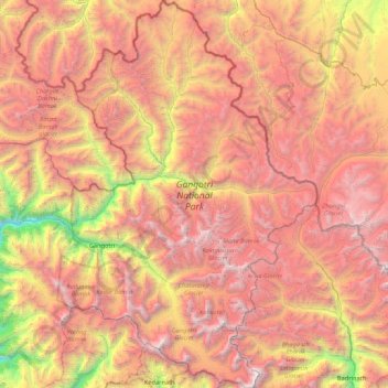
Name: Topografische Karte Gangotri National Park, Höhe, Relief.
Durchschnittliche Höhe: 5.008 m
Minimale Höhe: 2.497 m
Maximale Höhe: 7.135 m
The park harbors Western Himalayan subalpine conifer forests at lower elevations and Western Himalayan alpine shrub and meadows at higher elevations. Vegetation consist of chirpine deodar, fir, spruce, oak and rhododendrons.
Andere topografische Karten
Klicken Sie auf eine Karte, um ihre Topografie, ihre Höhe und ihr Relief anzuzeigen.
Didsari
India > Uttarakhand > Bhatwari
Didsari, Bhatwari, Uttarkashi district, Uttarakhand, India
Durchschnittliche Höhe: 1.801 m
Dayara
India > Uttarakhand > Bhatwari
Dayara, Bhatwari, Uttarkashi district, Uttarakhand, India
Durchschnittliche Höhe: 3.409 m
Uttarkashi
India > Uttarakhand > Bhatwari
Uttarkashi, Bhatwari, Uttarkashi district, Uttarakhand, 249193, India
Durchschnittliche Höhe: 1.619 m
Shivling
India > Uttarakhand > Bhatwari
Shivling, Bhatwari, Uttarkashi district, Uttarakhand, India
Durchschnittliche Höhe: 5.440 m
Gangotri
India > Uttarakhand > Bhatwari
Gangotri, Bhatwari, Uttarkashi District, Uttarakhand, India
Durchschnittliche Höhe: 4.139 m
Barsu
India > Uttarakhand > Bhatwari > Barsu
Barsu, Bhatwari, Uttarkashi, Uttarakhand, India
Durchschnittliche Höhe: 2.322 m
Raithal
India > Uttarakhand > Bhatwari > Raithal
Raithal, Bhatwari, Uttarkashi, Uttarakhand, India
Durchschnittliche Höhe: 2.122 m
Bhaironghati
India > Uttarakhand > Bhatwari > Lanka > Bhaironghati
Bhaironghati, Lanka, Bhatwari, Uttarkashi, Uttarakhand, India
Durchschnittliche Höhe: 3.227 m
Bhatwari
India > Uttarakhand > Bhatwari
Bhatwari, Uttarkashi district, Uttarakhand, India
Durchschnittliche Höhe: 4.572 m
Gangotri Glacier
India > Uttarakhand > Bhatwari
Gangotri Glacier, Bhatwari, Uttarkashi, Uttarakhand, India
Durchschnittliche Höhe: 5.259 m