
Topografische Karte Guímara
Interaktive Karte
Klicken Sie auf die Karte, um die Höhe anzuzeigen.
Über diese Karte
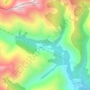
Name: Topografische Karte Guímara, Höhe, Relief.
Ort: Guímara, Peranzanes, El Bierzo, León, Castilla y León, España (42.87930 -6.70969 42.91930 -6.66969)
Durchschnittliche Höhe: 1.370 m
Minimale Höhe: 956 m
Maximale Höhe: 1.948 m
Andere topografische Karten
Klicken Sie auf eine Karte, um ihre Topografie, ihre Höhe und ihr Relief anzuzeigen.
Fresnedelo
España > Castilla y León > El Bierzo > Peranzanes
Fresnedelo, Peranzanes, El Bierzo, León, Castilla y León, 24429, España
Durchschnittliche Höhe: 1.070 m
Fornela
España > Castilla y León > El Bierzo > Peranzanes
Fornela, Peranzanes, El Bierzo, León, Castilla y León, 24429, España
Durchschnittliche Höhe: 1.178 m
Trascastro
España > Castilla y León > El Bierzo > Peranzanes
Trascastro, Peranzanes, El Bierzo, León, Castilla y León, 24429, España
Durchschnittliche Höhe: 1.181 m