
Topografische Karte Oulu
Interaktive Karte
Klicken Sie auf die Karte, um die Höhe anzuzeigen.
Über diese Karte
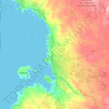
Name: Topografische Karte Oulu, Höhe, Relief.
Durchschnittliche Höhe: 46 m
Minimale Höhe: -2 m
Maximale Höhe: 195 m
Andere topografische Karten
Klicken Sie auf eine Karte, um ihre Topografie, ihre Höhe und ihr Relief anzuzeigen.
Kalajoki
Kalajoki, Ylivieska sub-region, North Ostrobothnia, Regional State Administrative Agency for Northern Finland, Mainland Finland, Finland
Durchschnittliche Höhe: 30 m
Pokelanmäki
Finland > North Ostrobothnia > Oulainen > Lehtopää
Pokelanmäki, Lehtopää, Oulainen, Ylivieska sub-region, North Ostrobothnia, Regional State Administrative Agency for Northern Finland, Mainland Finland, Finland
Durchschnittliche Höhe: 75 m
Kiiminki
Finland > North Ostrobothnia > Oulu
Kiiminki, Oulu, Oulu sub-region, North Ostrobothnia, Regional State Administrative Agency for Northern Finland, Mainland Finland, 90900, Finland
Durchschnittliche Höhe: 45 m
Vihanti
Vihanti, Raahe, Raahe sub-region, North Ostrobothnia, Regional State Administrative Agency for Northern Finland, Mainland Finland, 86400, Finland
Durchschnittliche Höhe: 88 m
Ruka
Finland > North Ostrobothnia > Kuusamo
Ruka, Kuusamo, Koillismaa sub-region, North Ostrobothnia, Regional State Administrative Agency for Northern Finland, Mainland Finland, 93830, Finland
Durchschnittliche Höhe: 319 m
Raahe
Raahe, Raahe sub-region, North Ostrobothnia, Regional State Administrative Agency for Northern Finland, Mainland Finland, Finland
Durchschnittliche Höhe: 30 m