Geolokalisieren

Topografische Karte Bancroft

Klicken Sie auf die Karte, um die Höhe anzuzeigen.

Über diese Karte

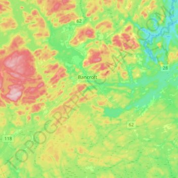
Name: Topografische Karte Bancroft, Höhe, Relief.

Ort: Bancroft, Hastings County, Central Ontario, Ontario, Canada (44.95205 -77.90515 45.13624 -77.63016)

Durchschnittliche Höhe: 370 m

Minimale Höhe: 283 m

Maximale Höhe: 518 m

👉 Easily get elevation data in JSON, GeoTIFF and KML formats using Elevation API
Vielen Dank für die Unterstützung dieser Website ❤️
Spenden

Rüsten Sie sich für Ihr nächstes Abenteuer:

Als Amazon-Partner erhält diese Website eine Provision für qualifizierte Käufe, ohne zusätzliche Kosten für Sie.

Andere topografische Karten

Klicken Sie auf eine Karte, um ihre Topografie, ihre Höhe und ihr Relief anzuzeigen.

Actinolite

Canada > Ontario > Hastings County > Tweed

Durchschnittliche Höhe: 175 m

East Tommy Lake

Canada > Ontario > Hastings County > Tudor and Cashel

Durchschnittliche Höhe: 378 m

Elzevir Lake

Canada > Ontario > Hastings County > Tweed

Durchschnittliche Höhe: 269 m

Monteagle Valley

Canada > Ontario > Hastings County > Hastings Highlands

Durchschnittliche Höhe: 398 m

Snake Lake

Canada > Ontario > Hastings County > Centre Hastings

Durchschnittliche Höhe: 187 m

Ivanhoe

Canada > Ontario > Hastings County > Centre Hastings

Durchschnittliche Höhe: 175 m

Boulter Lake

Canada > Ontario > Hastings County > Hastings Highlands

Durchschnittliche Höhe: 431 m

Mountain Lake

Canada > Ontario > Hastings County > Hastings Highlands

Durchschnittliche Höhe: 386 m

Shannonville

Canada > Ontario > Hastings County

Durchschnittliche Höhe: 87 m

Marmora

Canada > Ontario > Hastings County > Marmora and Lake

Durchschnittliche Höhe: 200 m

Maynooth

Canada > Ontario > Hastings County > Hastings Highlands

Durchschnittliche Höhe: 426 m

Inright Lake

Canada > Ontario > Hastings County > Hastings Highlands

Durchschnittliche Höhe: 424 m

Vielen Dank für die Unterstützung dieser Website ❤️
Spenden

Rüsten Sie sich für Ihr nächstes Abenteuer:

Als Amazon-Partner erhält diese Website eine Provision für qualifizierte Käufe, ohne zusätzliche Kosten für Sie.

Big Mink Lake

Canada > Ontario > Hastings County > Hastings Highlands

Durchschnittliche Höhe: 446 m

Coe Hill

Canada > Ontario > Hastings County > Wollaston

Durchschnittliche Höhe: 327 m

Gunter Lake

Canada > Ontario > Hastings County > Tudor and Cashel

Durchschnittliche Höhe: 273 m

Thomasburg

Canada > Ontario > Hastings County > Tweed

Durchschnittliche Höhe: 160 m

Vielen Dank für die Unterstützung dieser Website ❤️
Spenden

Roslin

Canada > Ontario > Hastings County > Centre Hastings

Durchschnittliche Höhe: 147 m

Queensborough

Canada > Ontario > Hastings County > Tweed

Durchschnittliche Höhe: 207 m

Boulter

Canada > Ontario > Hastings County > Carlow/Mayo

Durchschnittliche Höhe: 352 m

Marlbank

Canada > Ontario > Hastings County > Tweed

Durchschnittliche Höhe: 176 m

Ormsby

Canada > Ontario > Hastings County > Limerick

Durchschnittliche Höhe: 349 m

Fosters Lake

Canada > Ontario > Hastings County > Carlow/Mayo

Durchschnittliche Höhe: 302 m

Drag Lake

Canada > Ontario > Hastings County > Centre Hastings

Durchschnittliche Höhe: 184 m

Highway 7

Canada > Ontario > Hastings County > Highway 7

Durchschnittliche Höhe: 198 m

Madoc

Canada > Ontario > Hastings County > Centre Hastings > Madoc

Durchschnittliche Höhe: 172 m

Mawson Lake

Canada > Ontario > Hastings County > Tudor and Cashel

Durchschnittliche Höhe: 345 m

Rüsten Sie sich für Ihr nächstes Abenteuer:

🧦Kompressionsstrümpfe - Unterstützend bei langen Touren
🛰️GPS-Handgeräte - Robuste Navigationsgeräte für Wanderungen und Expeditionen
🆘Notfallpfeifen - Akustische Signale für Notfälle im unwegsamen Gelände
🔭Kinder-Ferngläser - Robuste Optik für kleine Entdecker
🔥Ultraleichter Campingkocher - Kompaktes Kochsystem für Rucksacktouren

Als Amazon-Partner erhält diese Website eine Provision für qualifizierte Käufe, ohne zusätzliche Kosten für Sie.