
Topografische Karte Bawiti
Interaktive Karte
Klicken Sie auf die Karte, um die Höhe anzuzeigen.
Über diese Karte
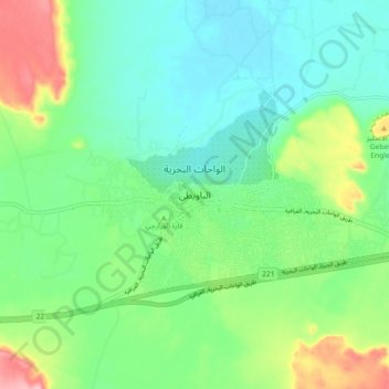
Name: Topografische Karte Bawiti, Höhe, Relief.
Ort: Bawiti, Giza, 12935, Egypt (28.31182 28.82299 28.39182 28.90299)
Durchschnittliche Höhe: 133 m
Minimale Höhe: 87 m
Maximale Höhe: 242 m
Andere topografische Karten
Klicken Sie auf eine Karte, um ihre Topografie, ihre Höhe und ihr Relief anzuzeigen.
Sheikh Zayed City
Egypt > Giza > Sheikh Zayed City
Sheikh Zayed City, Giza, 12593, Egypt
Durchschnittliche Höhe: 103 m
Smart Village
Egypt > Giza > Smart Village
Smart Village, Giza, 12577, Egypt
Durchschnittliche Höhe: 78 m
El Hassana Dome Protectorate
Egypt > Giza > Sheikh Zayed
El Hassana Dome Protectorate, Sheikh Zayed, Giza, Egypt
Durchschnittliche Höhe: 108 m
Al Hosary park
Egypt > Giza > Sixth of October
Al Hosary park, Neighborhood 1, 8th District, Sixth of October, Giza, Egypt
Durchschnittliche Höhe: 184 m
Nazlet Al Siman and Al Sisi
Egypt > Giza > Remaya Square
Nazlet Al Siman and Al Sisi, Remaya Square, Giza, Egypt
Durchschnittliche Höhe: 42 m