
Topografische Karte Lake Clark National Park and Preserve
Interaktive Karte
Klicken Sie auf die Karte, um die Höhe anzuzeigen.
Über diese Karte
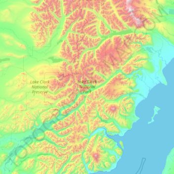
Name: Topografische Karte Lake Clark National Park and Preserve, Höhe, Relief.
Durchschnittliche Höhe: 673 m
Minimale Höhe: -1 m
Maximale Höhe: 3.463 m
Andere topografische Karten
Klicken Sie auf eine Karte, um ihre Topografie, ihre Höhe und ihr Relief anzuzeigen.
Glacier Bay National Park
Glacier Bay National Park, Hoonah-Angoon, Alaska, USA
Durchschnittliche Höhe: 556 m
Tanana River
USA > Alaska > Manley Hot Springs
Tanana River, Manley Hot Springs Road, Manley Hot Springs, Unorganized Borough, Alaska, 99756, USA
Durchschnittliche Höhe: 320 m
Anaktuvuk Pass
USA > Alaska > Anaktuvuk Pass
Anaktuvuk Pass, North Slope, Alaska, 99721, USA
Durchschnittliche Höhe: 743 m
Yukon River
Yukon River, Unorganized Borough, Alaska, 99740, USA
Durchschnittliche Höhe: 433 m
Catalina Island
Catalina Island, Prince of Wales-Hyder, Alaska, USA
Durchschnittliche Höhe: 123 m
Matanuska Glacier
Matanuska Glacier, Matanuska-Susitna, Alaska, USA
Durchschnittliche Höhe: 1.819 m
Chugach State Park at Cooper Landing
USA > Alaska > Cooper Landing
Chugach State Park at Cooper Landing, Cooper Landing, Kenai Peninsula, Alaska, USA
Durchschnittliche Höhe: 234 m
Alaska Peninsula
Alaska Peninsula, Lake and Peninsula, Alaska, USA
Durchschnittliche Höhe: 65 m
Yentna Glacier
Yentna Glacier, Matanuska-Susitna, Alaska, USA
Durchschnittliche Höhe: 1.529 m
Minnesota Park
Minnesota Park, Anchorage, Alaska, USA
Durchschnittliche Höhe: 29 m
Glennallen
USA > Alaska > Glennallen
Glennallen, Valdez-Cordova, Alaska, USA
Durchschnittliche Höhe: 442 m
King Salmon
USA > Alaska > King Salmon
King Salmon, Bristol Bay, Alaska, USA
Durchschnittliche Höhe: 18 m
Forrester Island
Forrester Island, Prince of Wales-Hyder, Alaska, USA
Durchschnittliche Höhe: 21 m
Kichatna Spire
Kichatna Spire, Matanuska-Susitna, Alaska, USA
Durchschnittliche Höhe: 1.893 m
Pogromni Volcano
Pogromni Volcano, Aleutians East, Alaska, USA
Durchschnittliche Höhe: 1.202 m
Princeton Glacier
Princeton Glacier, Unorganized Borough, Alaska, USA
Durchschnittliche Höhe: 621 m
Mount Natazhat
Mount Natazhat, Valdez-Cordova, Alaska, USA
Durchschnittliche Höhe: 3.336 m
Kenai Wilderness
Kenai Wilderness, Kenai Peninsula, Alaska, USA
Durchschnittliche Höhe: 304 m
Kagamil Island
Kagamil Island, Unorganized Borough, Alaska, USA
Durchschnittliche Höhe: 88 m
Chuginadak Island
Chuginadak Island, Unorganized Borough, Alaska, USA
Durchschnittliche Höhe: 102 m
Kuskokwim River
Kuskokwim River, Unorganized Borough, Alaska, USA
Durchschnittliche Höhe: 111 m
Gates of the Arctic
Gates of the Arctic, Unorganized Borough, Alaska, USA
Durchschnittliche Höhe: 665 m
Natazhat Glacier
Natazhat Glacier, Valdez-Cordova, Alaska, USA
Durchschnittliche Höhe: 2.633 m
Kobuk Valley National Park
Kobuk Valley National Park, Northwest Arctic, Alaska, USA
Durchschnittliche Höhe: 331 m
Hinchinbrook Island
Hinchinbrook Island, Valdez-Cordova, Alaska, USA
Durchschnittliche Höhe: 68 m
Gareloi Island
Gareloi Island, Unorganized Borough, Alaska, USA
Durchschnittliche Höhe: 281 m
Elfin Cove
USA > Alaska > Elfin Cove
Elfin Cove, Hoonah-Angoon, Alaska, USA
Durchschnittliche Höhe: 127 m
Lacuna Glacier
Lacuna Glacier, Matanuska-Susitna, Alaska, USA
Durchschnittliche Höhe: 1.676 m
Kagalaska Island
Kagalaska Island, Unorganized Borough, Alaska, USA
Durchschnittliche Höhe: 88 m
Stripe Mountain
Stripe Mountain, Prince of Wales-Hyder, Alaska, USA
Durchschnittliche Höhe: 244 m
LeConte Glacier
LeConte Glacier, Petersburg Borough, Alaska, USA
Durchschnittliche Höhe: 407 m