
Topografische Karte Knysna
Interaktive Karte
Klicken Sie auf die Karte, um die Höhe anzuzeigen.
Über diese Karte
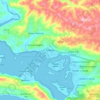
Name: Topografische Karte Knysna, Höhe, Relief.
Durchschnittliche Höhe: 95 m
Minimale Höhe: -3 m
Maximale Höhe: 311 m
Andere topografische Karten
Klicken Sie auf eine Karte, um ihre Topografie, ihre Höhe und ihr Relief anzuzeigen.
Noetzie
South Africa > Western Cape > Garden Route District Municipality > Knysna Local Municipality
Noetzie, Knysna Local Municipality, Garden Route District Municipality, Western Cape, South Africa
Durchschnittliche Höhe: 72 m
Forest Creek
South Africa > Western Cape > Garden Route District Municipality > Knysna Local Municipality
Forest Creek, Knysna Local Municipality, Garden Route District Municipality, Western Cape, South Africa
Durchschnittliche Höhe: 309 m
Sedgefield
South Africa > Western Cape > Garden Route District Municipality > Knysna Local Municipality
Sedgefield, Knysna Local Municipality, Garden Route District Municipality, Western Cape, 6573, South Africa
Durchschnittliche Höhe: 41 m