
Topografische Karte Water Mill
Interaktive Karte
Klicken Sie auf die Karte, um die Höhe anzuzeigen.
Über diese Karte
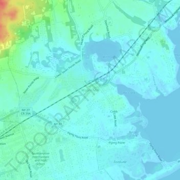
Name: Topografische Karte Water Mill, Höhe, Relief.
Ort: Water Mill, Suffolk County, New York, 11976, United States (40.88593 -72.38203 40.92593 -72.34203)
Durchschnittliche Höhe: 9 m
Minimale Höhe: -5 m
Maximale Höhe: 52 m
Andere topografische Karten
Klicken Sie auf eine Karte, um ihre Topografie, ihre Höhe und ihr Relief anzuzeigen.
Deerfield
United States > New York > Suffolk County > Water Mill
Deerfield, Water Mill, Town of Southampton, Suffolk County, New York, 11976, United States
Durchschnittliche Höhe: 27 m
Flying Point
United States > New York > Suffolk County > Water Mill
Flying Point, Water Mill, Town of Southampton, Suffolk County, New York, 11976, United States
Durchschnittliche Höhe: 4 m
Cobb
United States > New York > Suffolk County > Water Mill
Cobb, Water Mill, Town of Southampton, Suffolk County, New York, 11976, United States
Durchschnittliche Höhe: 5 m