
Topografische Karte Town of Shelburne
Interaktive Karte
Klicken Sie auf die Karte, um die Höhe anzuzeigen.
Über diese Karte
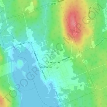
Name: Topografische Karte Town of Shelburne, Höhe, Relief.
Ort: Town of Shelburne, Shelburne County, Nova Scotia, Canada (43.74952 -65.34439 43.78805 -65.29645)
Durchschnittliche Höhe: 28 m
Minimale Höhe: -1 m
Maximale Höhe: 91 m
Andere topografische Karten
Klicken Sie auf eine Karte, um ihre Topografie, ihre Höhe und ihr Relief anzuzeigen.
Granite Village
Canada > Nova Scotia > Shelburne County
Granite Village, Municipality of the District of Shelburne, Shelburne County, Nova Scotia, B0T 1J0, Canada
Durchschnittliche Höhe: 35 m
Rockland
Canada > Nova Scotia > Shelburne County
Rockland, Municipality of the District of Shelburne, Shelburne County, Nova Scotia, B0T 1V0, Canada
Durchschnittliche Höhe: 12 m
Arnold
Canada > Nova Scotia > Shelburne County > Little Harbour
Arnold, Little Harbour, Municipality of the District of Shelburne, Shelburne County, Nova Scotia, B0T 1V0, Canada
Durchschnittliche Höhe: 2 m
Stoney Island
Canada > Nova Scotia > Shelburne County
Stoney Island, Municipality of the District of Barrington, Shelburne County, Nova Scotia, B0W 1P0, Canada
Durchschnittliche Höhe: 3 m
Upper Port La Tour
Canada > Nova Scotia > Shelburne County
Upper Port La Tour, Municipality of the District of Barrington, Shelburne County, Nova Scotia, B0W 3N0, Canada
Durchschnittliche Höhe: 5 m
Lockeport
Canada > Nova Scotia > Shelburne County
Lockeport, Shelburne County, Nova Scotia, B0T 1L0, Canada
Durchschnittliche Höhe: 7 m
Louis Head
Canada > Nova Scotia > Shelburne County
Louis Head, Municipality of the District of Shelburne, Shelburne County, Nova Scotia, Canada
Durchschnittliche Höhe: 7 m
Locke Island
Canada > Nova Scotia > Shelburne County > Lockeport
Locke Island, Lockeport, Shelburne County, Nova Scotia, B0T 1L0, Canada
Durchschnittliche Höhe: 2 m
Sable River
Canada > Nova Scotia > Shelburne County
Sable River, Municipality of the District of Shelburne, Shelburne County, Nova Scotia, B0T 1J0, Canada
Durchschnittliche Höhe: 50 m
East Side of Ragged Island
Canada > Nova Scotia > Shelburne County
East Side of Ragged Island, Municipality of the District of Shelburne, Shelburne County, Nova Scotia, B0T 1V0, Canada
Durchschnittliche Höhe: 1 m
Ingomar
Canada > Nova Scotia > Shelburne County
Ingomar, Municipality of the District of Shelburne, Shelburne County, Nova Scotia, B0T 1W0, Canada
Durchschnittliche Höhe: 5 m
East Sable River
Canada > Nova Scotia > Shelburne County
East Sable River, Municipality of the District of Shelburne, Shelburne County, Nova Scotia, B0T 1V0, Canada
Durchschnittliche Höhe: 17 m
Lower Ohio
Canada > Nova Scotia > Shelburne County > Lower Ohio
Lower Ohio, Municipality of the District of Shelburne, Shelburne County, Nova Scotia, B0T 1W0, Canada
Durchschnittliche Höhe: 53 m
South Side
Canada > Nova Scotia > Shelburne County
South Side, Municipality of the District of Barrington, Shelburne County, Nova Scotia, B0W 1P0, Canada
Durchschnittliche Höhe: 3 m