
Topografische Karte Saint Petersburg
Interaktive Karte
Klicken Sie auf die Karte, um die Höhe anzuzeigen.
Über diese Karte
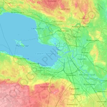
Name: Topografische Karte Saint Petersburg, Höhe, Relief.
Durchschnittliche Höhe: 40 m
Minimale Höhe: -8 m
Maximale Höhe: 171 m
The elevation of Saint Petersburg ranges from the sea level to its highest point of 175.9 m (577 ft) at the Orekhovaya Hill in the Duderhof Heights in the south. Part of the city's territory west of Liteyny Prospekt is no higher than 4 m (13 ft) above sea level, and has suffered from numerous floods. Floods in Saint Petersburg are triggered by a long wave in the Baltic Sea, caused by meteorological conditions, winds and shallowness of the Neva Bay. The five most disastrous floods occurred in 1824 (4.21 m or 13 ft 10 in above sea level, during which over 300 buildings were destroyed), 1924 (3.8 m, 12 ft 6 in), 1777 (3.21 m, 10 ft 6 in), 1955 (2.93 m, 9 ft 7 in), and 1975 (2.81 m, 9 ft 3 in). To prevent floods, the Saint Petersburg Dam has been constructed.
Andere topografische Karten
Klicken Sie auf eine Karte, um ihre Topografie, ihre Höhe und ihr Relief anzuzeigen.
Palace District
Russia > Saint Petersburg > Palace District
Palace District, Центральный район, Saint Petersburg, Northwestern Federal District, 190000, Russia
Durchschnittliche Höhe: 8 m
Екатерингофский округ
Russia > Saint Petersburg > Екатерингофский округ
Екатерингофский округ, Адмиралтейский район, Saint Petersburg, Northwestern Federal District, 190000, Russia
Durchschnittliche Höhe: 8 m