
Topografische Karte Annandale
Interaktive Karte
Klicken Sie auf die Karte, um die Höhe anzuzeigen.
Über diese Karte
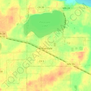
Name: Topografische Karte Annandale, Höhe, Relief.
Ort: Annandale, Wright County, Minnesota, 55302, United States (45.24523 -94.15210 45.28310 -94.08800)
Durchschnittliche Höhe: 323 m
Minimale Höhe: 300 m
Maximale Höhe: 339 m
Andere topografische Karten
Klicken Sie auf eine Karte, um ihre Topografie, ihre Höhe und ihr Relief anzuzeigen.
Rockford
United States > Minnesota > Wright County
Rockford, Wright County, Minnesota, United States
Durchschnittliche Höhe: 296 m
Delano
United States > Minnesota > Wright County
Delano, Wright County, Minnesota, 55328, United States
Durchschnittliche Höhe: 289 m
Otsego
United States > Minnesota > Wright County
Otsego, Wright County, Minnesota, United States
Durchschnittliche Höhe: 281 m
Monticello Township
United States > Minnesota > Wright County
Monticello Township, Wright County, Minnesota, United States
Durchschnittliche Höhe: 297 m
Albertville
United States > Minnesota > Wright County
Albertville, Wright County, Minnesota, 55301, United States
Durchschnittliche Höhe: 292 m
Hanover
United States > Minnesota > Wright County
Hanover, Wright County, Minnesota, 55341, United States
Durchschnittliche Höhe: 291 m
Montrose
United States > Minnesota > Wright County
Montrose, Wright County, Minnesota, United States
Durchschnittliche Höhe: 294 m
Howard Lake
United States > Minnesota > Wright County
Howard Lake, Wright County, Minnesota, 55349, United States
Durchschnittliche Höhe: 312 m
Buffalo
United States > Minnesota > Wright County
Buffalo, Wright County, Minnesota, 55313, United States
Durchschnittliche Höhe: 297 m
Silver Creek Township
United States > Minnesota > Wright County
Silver Creek Township, Wright County, Minnesota, 55380, United States
Durchschnittliche Höhe: 303 m
Albion Center
United States > Minnesota > Wright County
Albion Center, Albion Township, Wright County, Minnesota, United States
Durchschnittliche Höhe: 320 m
St. Michael
United States > Minnesota > Wright County
St. Michael, Wright County, Minnesota, 55376, United States
Durchschnittliche Höhe: 290 m
Maple Lake Township
United States > Minnesota > Wright County
Maple Lake Township, Wright County, Minnesota, 55358, United States
Durchschnittliche Höhe: 310 m
Monticello
United States > Minnesota > Wright County
Monticello, Wright County, Minnesota, 55362, United States
Durchschnittliche Höhe: 289 m
South Haven
United States > Minnesota > Wright County
South Haven, Wright County, Minnesota, United States
Durchschnittliche Höhe: 333 m
Maple Lake
United States > Minnesota > Wright County > Maple Lake > Maple Lake
Maple Lake, Wright County, Minnesota, 55358, United States
Durchschnittliche Höhe: 314 m
South Haven
United States > Minnesota > Wright County > South Haven > South Haven
South Haven, Wright County, Minnesota, 55382, United States
Durchschnittliche Höhe: 331 m
Rockford
United States > Minnesota > Wright County > Rockford > Rockford
Rockford, Wright County, Minnesota, 55313:55373, United States
Durchschnittliche Höhe: 298 m
Annandale
United States > Minnesota > Wright County > Annandale > Annandale
Annandale, Wright County, Minnesota, 55302, United States
Durchschnittliche Höhe: 324 m
Maple Lake
United States > Minnesota > Wright County
Maple Lake, Wright County, Minnesota, United States
Durchschnittliche Höhe: 314 m